
The furthest north I’ve been in the Park is *pauses* *looks at map* very far south. Basically my entire tripping experience has been within a few days’ paddle of the highway 60 corridor. As far as I was concerned the Park might as well have ended at Big Trout with nothing but a barren wasteland filled with swirling lava storms and canoe eating space monkeys beyond. Turns out that was wrong.
Once my wife convinced me that the space monkeys were a thing I just made up, and that the there hadn’t been a lava storm since ’06, she and I decided to drive up to Access Point 1 (Kawawaymog Lake) in the northwest corner of the Park to see what I’d been missing. A lot, it seems.

Kawawaymog is not actually part of Algonquin Park. You get to it by driving up Highway 11 to South River, then east from South River along a gravel road that was apparently designed with the sole purpose of shaking your canoe off the roof of your vehicle. The access point is beside an outfitter filled with friendly staff and astronomically expensive bug juice. We arrived at the access point at around 9:00 am and quickly hit the water. (Not literally. My paddling style is much more graceful than that. Like a moose doing ballet. On water. Or something.)
It’s about two and a half km across Kawawaymog from the access point to the start of the “river” that leads into North Tea. We had a decent tailwind (remember that, it’s important) so the paddle across went fairly quickly. Kawawaymog is a nice enough lake, although I generally prefer water with less than 1000 bits of floating gunk per square foot.

Between Kawawaymog and North Tea is the Amable Du Fond River (French for Aggravating as Fuck River). It’s 3 or 4 km, the first half of which is a winding creek that would be really frustrating with low water levels. There were low water levels. And bugs. So many bugs. About five minutes into the creek we came to a large beaver dam and a larger swarm of black flies. It was at about this point that my wife started wondering why she’d agreed to come on this trip. We lifted over and spent the next half hour poling along the creek through very shallow water (or very deep mud, depending on your point of view). It was at about this point that my wife started wondering why she’d agreed to marry me.
Fortunately for everyone involved, the river opens up about halfway between Kawawaymog and North Tea. There’s a split at this point with a sign pointing in the right direction, which would be super helpful if the sign weren’t basically invisible. So make sure you keep right if you don’t want to end up a literal shit’s creek. There are a couple of small portages the rest of the way, but nothing too difficult. The wildlife diversifies a bit at around this point as well, expanding from bugs to include things that are not bugs. We saw a moose and a beaver, neither of whom were half as excited to see me as I was to see them.

North Tea lake is a wonderful change from the Amable du Fond. It’s big. Like, Andre the Giant circa 1987 big. From the portage the far shore is a thin line on the horizon, and then you realize that you’re only looking at the other side of the west arm of the lake and that the east arm is out of sight around the corner. Like I said, North Tea is big. We got out on the water, grateful for the tailwind that helped us along and, more importantly, seemed to have blown all the bugs off the lake. We paddled for a while without a destination in mind, just enjoying the water, the sun and the ability to paddle for ten feet in any direction without having to jackknife around a stand of swamp grass.
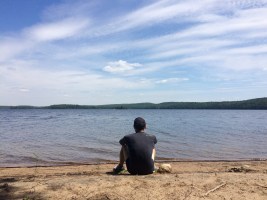
By this point it was lunch o’clock. We found a nice (bug free) campsite with a wide beach on the north shore of the west arm and stopped for sandwiches and a swim. We checked out a few campsites around the lake over the course of the day and they were all really good. Lots of flat areas, well maintained; the ones with beaches are excellent for swimming and getting sand in your socks. It seems like a great lake to visit for both the quality of the camp sites and the privacy. We saw only a couple of other trips while were out, and for the most part those were just distant dots on the water. Probably has something to do with the American Ninja Warrior of a shitwater obstacle course that is the Amable Du Fond. If you can’t get to a place you sure can’t mess it up.
After lunch we decided to take a side trip up to Lost Dog Lake. Our Jeff’s Map showed the ruins of an old logging camp behind one of the sites on Lost Dog and that seemed like as good a reason as any to push on. It wasn’t. It turned out that all the bugs that had been blown off of North Tea had been blown onto the portage leading into Lost Dog. There is also a small pond in the middle of that portage that you have to paddle across and which is, as we discovered as we pulled out on the other side, swarming with leeches. If you’ve ever wanted to reenact the leech scene from Stand By Me, this is the perfect place to do it.¹

Lost Dog is a nice enough lake, but after visiting it I don’t know that I ever need to go back. From what we saw, the sites on Lost Dog don’t really compare to the ones on North Tea. We found the site where the old logging camp was meant to be, but no ruins (unless you count the old wine bottle I found stuffed in a stump near the campsite). Still, I’m glad we made the trip up.
Back on North Tea we discovered that the tailwind we’d enjoyed all day had become a headwind now that we were heading back to the access point (it got particularly strong as we were crossing Kawawaymog, which is exactly what you want at the end of an eight hour day). We paddled back towards the portage on North Tea with a quick stop to check out a ranger cabin at the western end of the lake. The cabin is on a great beach and would be a perfect place to camp for the night, but as far as I can tell it’s not one of the cabins the park rents. (Update: I’ve updated this paragraph a bit since the original one was mistaken in a bunch of ways based on me thinking it was part of the Park. It turns out that this wasn’t actually a ranger cabin. It wasn’t even part of the Park. The Park ends where the water ends at this part of North Tea. This was, in fact, someone’s summer cottage. I found this out because they took the time to email me in April of 2017, when they found this blog post, and (Very nicely) filled me in on the history of their property. So, yeah, note to future Drew, pay a bit more attention to the map from now on).


All in all, it was another great day on the water. We didn’t see all of North Tea, which just means that I’ll have to go back some day.
 Twenty-two down, seventy-eight to go.
New Lakes Paddled: 2
Total Lakes Paddled: 5
Total Portages: 6
Total Distance Portaged: 2.130 km
Total Distance Covered: 23.6 km
Another great trip story Drew. I have camped on North Tea, a fine body of water indeed!
Hi Greg, I heard about you today from a neighbour of mine in Muskoka and I would love to connect with you by phone. Can you please send me your contact info? I’ll be upon the Park this week
Hi David. Not sure if you’re trying to get ahold of me or the person whose comment you were replying to, but if it’s me then I’m happy to connect by email if you’ve got any questions about the park. Allofalgonquin@gmail.com.
This is an amazing adventure. I’m really enjoying the descriptions of lakes I haven’t visited and reminders of lakes I have paddled. Good luck.
Thanks Guy, any recommendations for lakes I haven’t seen yet?
Maple Lake was one of my favourites. Perhaps because we had a great island camp site and we arrive early so had the day to relax.
Is eustache in your list? Deepest in the park with exceptionally clear water! Worth the effort, including the huge rock “bowl” on the north side of the lake.
I’ve always wanted to see Eustache but probably won’t get up there this summer. It’s on the list for next summer.
hi 🙂 I know this is an old post, but do you remember the campsite you mentioned with the nice beach? I’m heading up there in a few days and would love to know which one it was!
Thanks for the awesome blog post! Very fun to read 🙂
Hi Caryn, thanks! I’m glad you liked the post. That beach, it turns out, is actually private property and not even part of the Park. Apparently the Park ends at the shore on that part of North Tea.
Oh! I was referring to what you mentioned as ‘the campsite that was on the Northshore of the west arm’.. that was private property?
Thanks 🙂
Hey Caryn, I’m sorry, I should have reread my post before replying. You’re absolutely right, I was thinking of the wrong spot. That site is very much part of the Park. I don’t remember which one it is exactly, but it’s before the portage up to Lost Dog, so if you get there you’ve gone too far. Hope you have a great trip!
hi 🙂 I know this is an old post, but do you remember the campsite you mentioned with the nice beach? I’m heading up there in a few days and would love to know which one it was!
Thanks for the awesome blog post! Very fun to read 🙂
Hi all! We are heading out to North Tea East shore in a few days. Looking for a site with an awesome beach. Can anyone tell me a campsite number to aim for??
Please and thank you!
Kayla
Hi Kayla,
Unfortunately I’ve only seen parts of North Tea (it’s really big!) and I can’t think of a good beach site on the east arm off the top of my head. Check out the Algonquin Adventures campsite inventory, there are a few site reviews for north yea there that might have some information. http://www.algonquinadventures.com/PCI/PCIindex.htm
Drew