I’ve never seen Swan Lake the ballet performance. I know it’s super famous and I know (thanks to Wikipedia) that it was written by Tchaikovsky based on something he’d created for his nieces and nephews, but I have no idea what it’s about. I’ve always assumed it to basically be Shark Night, but with swans (if it isn’t, it should be). I had also never before seen Swan Lake, the Algonquin lake and, until recently, I didn’t know much about it either. However, unlike Swan Lake the (hopefully) blood drenched action-horror ballet performance, there is no Wikipedia page for Swan Lake the Algonquin lake, so this past Canada Day weekend I decided to go find out about it for myself.

There’s a couple of things you should know about Swan Lake. First, it’s really close to the Canoe/Smoke access point. It’s actually a relatively good sized lake nestled in between Tea Lake and Smoke Lake, just south of highway 60. However, it’s not part of a defined canoe route, which leads to the second thing you should know about Swan Lake: getting there is work. Like, pushing up a steep hill through a wall of branches while the Swan Lake mosquito defense corps attacks you from every angle type of work. In other words, it isn’t exactly a walk in the park. Or, more accurately, it is exactly a (long, hard, kinda hard to find) walk in the Park. But it’s worth it.
I set off from Canoe Lake just after sunrise. Canada Day weekend 2018 was, as you may recall, hot AF. Even at that early hour the air was thick; it felt like I wasn’t so much paddling on the water as I was paddling inside a slightly thinner layer of the lake. You could see the faint yellow tiddly-wink disc outline of the sun through the grey haze overhead, promising another scorcher of a day once it burned through the mist. While there was no wind to push away the heat, there was also no wind to disturb the glass-like surface of the water as I paddled south from Canoe Lake into Bonita Lake and it made for a very peaceful (but also immediately sweaty) start to the day.

Canoe, Bonita and Tea Lake are all connected by a stretch of the Oxtongue River. This means there are no portages along the way, and it doesn’t take long to get through each of them. Bonita is basically just a large-ish bay sticking out from the side of the river about halfway between Canoe and Tea Lake. It’s home to a cottage, some picturesque stumps standing guard mid-river and not much else. There’s a marshy area on the west side of the river that looks like it’d be a great place to try and see some wildlife, although the only thing I saw as I paddled past was a solitary loon floating lazily between the stumps and making it very clear that it was ignoring me. Loons are stuck up like that.

It’s a quick paddle from Canoe through Bonita and into Tea. Tea Lake is interesting. Like many of the other lakes around the Canoe/Smoke access point, if it were in the middle of the Park I bet it would be a favourite destination for many trippers. It’s a big, beautiful lake with lots of nearby options for exploration and some gorgeous scenery to boot. However, it’s not in the middle of the Park. In fact. it’s directly beside highway 60 and is also home to a number of cottages and a large (American Pie Famous) camp. And, while there are good exploration options in the area, it’s not really en route to any paddling destinations. As a result, I bet a lot of folks don’t bother with Tea Lake, which is a shame, because it’s well worth the visit (especially in the fall, when the scenery is breathtaking).
I had Tea Lake to myself as I paddled out of the river. The sun was still trying to burn through the grey and I was already starting to wonder which would melt away first, me or the haze. My destination was a small inlet towards the eastern side of Tea that ended up against Highway 60. Coot Lake, a small little body of water/mosquito breeding ground, lay on the other side of the highway and marked the beginning of my off route travelling for the day. I paddled to the end of the inlet, found a spot to pull up in the tall grass and was immediately swarmed by a cloud of bugs that must have been out for their morning jog along the highway.


Portaging from Tea Lake to Coot is pretty easy. It’s a short walk up the highway embankment, a short walk across the highway, and a short walk down the other side to Coot Lake, interrupted, of course, by a ten minute search through the tall grass to find the GoPro you somehow managed to drop between one side of the highway and the other. You know what’s fun? Getting absolutely savaged by mosquitoes as you retrace your steps back and forth across the highway until you finally find what you’re looking for about five feet from where you put your pack down to start the search. That’s fun.
One thing to think about if you’re going to try this: this isn’t the best place to cross highway 60. You’re at the bottom of a curving hill in both directions, which means that vehicles coming along aren’t going to have a ton of time to see you and are probably going to be going a bit faster than they might normally because of the downslope. It’s hard to react quickly when you’ve got a canoe on your head, so be really, really careful if you decide to make the crossing. Also, maybe put some kind of homing beacon on any camera equipment you plan on dropping.

I pushed off on Coot Lake and paddled towards the middle. Coot isn’t that big, but it’s quite pretty, particularly once you get out of the narrow northern part. I was sharing the lake with a couple of loons and quite a few mosquitoes, but apart from that it felt like I was alone somewhere deep in the wild. That feeling got a bit harder to maintain as a truck roared past on highway 60, reminding me that the Park’s main roadway was less than 100m behind me, but it was definitely cool while it lasted.
I stuck close to the western shore and paddled down Coot, looking for a good spot to start my portage across to Swan Lake. Using the ancient navigation technique of staring blankly at the map then guessing blindly, I thought it was probably about a kilometer between Coot and Swan. The map shows a road just over half way between the two, so I figured my main goal should be to make it the 500 metres to that road without getting lost, eaten or lost, then eaten. Assuming I could do that, I could follow the road most of the rest of the way to Swan. This meant that, really, I was only looking at a 500 metre bushwhack, which, from the comfort of my canoe, seemed reasonable. The sound I couldn’t quite hear as I paddled towards the spot I’d picked to start my portage was Immediate Future Me, tangled up in a spiderweb of branches and dead undergrowth, screaming at Overly Confident Past Me that 500 metres of bushwhack is never reasonable. Never.


I pulled up on shore and scouted the immediate area, looking for a good path through the forest. I found what I thought was a decent option, went back to grab my pack and canoe, and started off into the trees. It was smooth sailing for the first 20 meters or so. Then it was the opposite of smooth sailing. Hurricane sailing? It was hurricane sailing. I came to a spot where multiple trees had fallen, creating a wall of branches and sharp stabby things that I tried to push through with minimal success, so I backed up and tried another route that looked promising. And then I did it again. And again. And again. Twenty minutes and multiple lacerations later I was back where I started the portage, licking my wounds and convincing myself that Swan Lake probably sucked anyways.
Then I saw the flagging tape.

The reason the spot I’d picked looked like a decent portage takeout is because it might actually be a portage takeout. There’s a path leading away from the water that’s kind of like those old magic eye pictures. You only really notice it if you stare long enough and go kinda cross eyed. But it’s there. And so is the flagging tape; a thin yellow strip (or maybe pink, I saw both along the way) of hope about ten meters down the trail, promising at the very least that someone else had at one point or another decided that it would be a fun idea to stumble through the woods between Coot and Swan. With a renewed sense of optimism, and the bleeding slowing, I picked up my canoe and pack and set off down the yellow (and pink) tape trail.
Even with the benefit of a (sporadically) marked trail, this wasn’t an easy carry. I lost track of the flagging tape a bunch of times. Either I’m not that observant (definitely a possibility) or whoever flagged that path got bored of doing it at intermittent intervals along the way. There are long stretches where I couldn’t see the next strip of tape and had to just push forward in what I hoped was the right direction. This meant sidestepping up hills, wading through shin deep swampmoss pool parties, pushing through deadfalls and suddenly getting yanked backwards when the rope I didn’t realize I’d been dragging knotted itself around a branch/rock/portage gremlin. Every time I stopped to get my bearings the bugs would be waiting to swarm me and, to top it all off, there was a distressing amount of uphill, particularly over the last couple hundred meters approaching the access road.

Despite the challenges, and with the bug-free clarity of hindsight, this was a really fun experience. I wouldn’t call it a true bushwhack because there definitely are markers along the way, but it had a bunch of elements of a bushwhack and the forest in between Coot and Swan is beautiful. This area is part of the Swan Lake Forest Research Reserve, a 2,000 ha experimental forest established back in 1950 to study the mature hardwood forests in the area. As a result of this protection, the forest really does feel older than some of the other parts of the Park you might portage through. I was too busy sweating, swearing and trying not to trip to stop and take pictures, but there are some pretty spectacular old trees and swampy wetland areas along the way that you wouldn’t find on a more heavily trafficked route.
I have to admit, after spending most of the walk up from Coot Lake tripping into cleverly hidden holes in the ground and running into tree branches, I was 100% done with appreciating the nature around me by the time I stumbled out onto the road. Nature, unfortunately, was not done with appreciating me as the ubiquitous swarm of mosquitoes that had followed me from Coot seemed to somehow gain in strength as I made my way along the road. The good news is that from that point on things went pretty much according to plan. I followed the road until I found a sign pointing towards Swan lake, then followed a much more overgrown road down to the water’s edge. I put down my canoe, snapped a couple of pictures with one hand and swatted mosquitoes with the other, and pushed off onto Swan Lake.

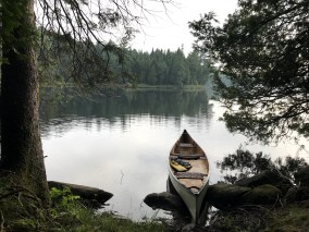
Here’s the thing you realize about Swan Lake once you get a few strokes away from shore: it’s worth the effort. It’s a beautiful, decent sized lake that could probably hold quite a few campsites without seeming crowded. As it is, the only crowds on Swan Lake are the birds. As I paddled across the lake I was serenaded by a constant stream of bird calls. Seagulls and loons were everywhere; at one point I actually thought a low flying seagull might crash into me, but it swerved at the last minute, giving me the finger as it went by.
Almost as soon as I left shore I had noticed another sound beneath the bird calls. It was kind of like a really poorly trained orchestra of frogs and ducks tuning up, and it grew louder and louder as I approached the middle of the lake. There’s a small island there, not much more than a few trees and bushes, but one of those trees was home to a large osprey (I think, definitely not a swan) nest that was the source of the sound. I watched from my canoe as an adult osprey flew to and from the nest, bringing food to the chicks who were practicing their bullfrog impressions inside. I’ve never come across something like that before, so it was pretty cool to just sit and watch for a while. Sadly, as this guy so poignantly taught us, all good things must end and I eventually realized that mama osprey wasn’t going to be throwing any of that breakfast my way so if I wanted to eat that morning I’d have to continue on and finish my loop.
I paddled the rest of the way across Swan to the eastern shore. My goal was to find a decent take out and make my way over to Little Smoke Lake, a small lake in between Swan and Smoke. Jeff’s Map shows a historic route between Swan, Little Smoke and Smoke and I was hoping to find traces of that route or, at the very least, fewer bugs on this side of the lake than there had been on the other side. I lucked out on both counts. Almost exactly where the map showed it would be I found the start of a clearly marked trail. I also found out that trying to balance on the very tip of your canoe’s bow as you exit the boat for shore isn’t the best idea.
Once I’d dragged myself from the water and confirmed that I hadn’t broken anything (on me or the canoe), I picked up the boat and started down the path to Little Smoke. It wasn’t too long before I saw an opening in the trees ahead that I assumed would be Little Smoke. What I found instead was a small meadow and a path that just kind of disappeared. I also found all the bugs that had been missing from the start of the portage. I put the boat down, scouted around a bit and finally found the trail on the other side of the meadow. Still optimistic that I was getting close to Little Smoke, I flipped the boat back up and carried on my way.

On the map it looks like maybe 300-400m between Swan and Little Smoke. That may very well be true. However, it turns out that the path I was following had zero interest in taking me to Little Smoke. After about 500m I began to get suspicious. After about 700m, the last 100m of which had been up and across the side of a pretty steep ridge, I began to swear. After about 800m, as I realized that I’d somehow lost the trail, I put the canoe down, pulled out my GPS and confirmed that I was nowhere near Little Smoke, and likely never would be. Turns out I was following a path that had (probably) been flagged by someone who wanted a nice little hike between Swan Lake and their cottage on Smoke Lake. My easy pair of 300m portages sandwiched around a nice short paddle was in reality a not so easy pair of 300m portages sandwiched around another 500m+ portage and garnished with mosquitoes.
Realizing that I wasn’t going to get to Little Smoke was a bit of a disappointment. Also disappointing, realizing that the portage, somehow, seemed to only go uphill, even when it was going downhill, and I had no idea how much I had left on it. There were, of course, some fun little low lying areas that looked solid and not at all like the secret moss covered water traps that they were, but by and large this was more of a climb than it was a wade. By the time I fought my way down the last, steep slope to Smoke (I didn’t want to follow the path all the way back to the person’s cottage and interrupt their breakfast with my sweating/swearing/sobbing) I was drenched with sweat, covered in bugs and feeling really glad that I’d spent as much time appreciating Swan Lake as I did, because the only way I’d be going back is if someone catapulted me there.

The paddle back up Smoke Lake was relatively slow. I took it easy, enjoying the fact that the canoe was under me instead of on top of me, and stopped a few times to let the (slight) breeze push me back to the access point. Once I was there, it was a quick carry across to Canoe Lake and the end of the trip.
All in all, and despite some of the more challenging moments mid portage, this was a lot of fun. I’ve never been off of a canoe route in the Park before and there’s something very exciting about stepping away from those little yellow lines and pushing into the (sort of) unknown. That being said, there’s also something a little frightening about it as well. The odds of help coming along if you fall and break a leg or dump your boat are pretty low. There’s no one out there but you and the birds (well, and an entire civilization of mosquitoes) and that can be a problem if things go wrong (but let’s not overstate this either, Swan Lake isn’t exactly buried deep in the Algonquin wilds). Fortunately things didn’t go wrong (unless you count the portage to Little Smoke that wasn’t) and it was a fantastic way to spend the morning. I don’t know if I’ll be back to Swan Lake any time soon, but I do know that the mosquitoes living in the woods just west of Smoke Lake haven’t seen the last of me. Little Smoke isn’t going to find itself.
 174 Down.
New Lakes Paddled: 2
Total Lakes Paddled: 6
Total Portages: 3
Total Portage Distance: 3.16 KM
Total Travel Distance: 16.6 KM
“I stuck close to the western shore and paddled down Coot, looking for a good spot to start my portage across to Swan Lake. Using the ancient navigation technique of staring blankly at the map then guessing blindly, I thought it was probably about a kilometer between Coot and Swan.”
😂😂😂😂 Yes!!!!!
How long did the whole loop take you to do?
Thanks! The loop took about 4 hours, half of which were spent being irrationally angry at various rocks, roots and branches.
Great read as always Drew, really enjoy your trip stories & photos, look forward to every installment. Thanks for sharing.
Thanks Jim!
Great reviews! Have read them all now and pretty sure I enjoyed every one ((can’t recall 🙂 which is why the new cross referencing and categorizing is so great, not to mention extra parentheses). I was surprised that you make no mention of “Jerry’s Treasure Adventure” in Canoe Bay. Seems like that is teed up pretty high to ignore. Not sure what this is but when I noticed it on your map snippet it certainly caught my eye. Hopefully there’ll be an exciting explanation on Jeff’s map.
Thanks Gord! Among other things, Jerrys’ Treasure Adventure is an amazing name for a pirate themed restaurant. I think in this case though it’s the name of three islands that are close together. Jeff’s Map only has the I for island, which is why it’s easy to miss, especially on my map snippets.