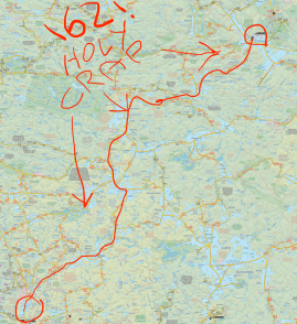
The Brent Run is a legendary canoe trip through the heart of Algonquin. The idea is to get from Canoe Lake to the old town of Brent on Cedar Lake, and back, in as short a time as possible, and, I guess, without having a heart attack. There’s a route you’re meant to follow that covers about 162 KM in total, and the record for completing it is 23 hours and change. 23 hours to paddle and portage 162 kilometres. The world record for swallowing swords simultaneously is 29, which is equally insane. Regardless, the Brent Run is totally a thing, and I’m in awe of people who can get that done.
This trip was not that.
This trip did, however, start at Canoe Lake and end at Cedar, and is about as close as I’ll ever get to doing the Run, so strap on your knee pads, we’re doing the Brent Crawl.

The plan was to spend the better part of a week in the Park. I’d start with an overnight with my daughter, then solo my way up to Cedar over the course of a few days. I would then meet up with some buddies for a couple more days of paddling in the Brent area.
I started Sunday afternoon with a quick paddle over to Joe Lake. This was the overnight with my daughter, a sort of make up trip for the Sec Lake one that got cut short earlier this year. I must be doing something right, because my daughter absolutely loves camping. She’s a complete pro on portages and the camp site, and totally doesn’t mind when her old man drops hot dogs in the fire.
I can’t remember the last time I camped on Joe Lake, but it’s actually pretty nice. We got a spot on the north shore of the east arm, about halfway towards Little Joe. It’s a good site, with decent views, good swimming and a pre-existing bear hang rope (for a more detailed review, check out the campsite report). We had a pleasant evening cooking mac and cheese (both of us), dropping hot dogs in the fire (me), smearing marshmallows on our faces (her … sigh, fine, also me) and swimming (both of us again).


Towards the end of the night we got to watch a mother moose and her mooselet swimming down the centre of Joe Lake. They took a hard right and came ashore in the bay across from us where they settled down for an evening snack. That was pretty cool. The next morning we got a beautiful sunrise that we watched from the canoe, then headed back to Canoe Lake for the traditional next leg of any canoe trip: a side trip to Santa’s Village in Bracebridge.
Having visited Santa in his summer home, it was time to start the solo part of my week. My original route was pretty ambitious and, it turned out, impossible to stick to. I ended up leaving a day later than expected, which tightened up my already fairly tight timing. Also, because I’m desperately afraid of being hungry on trip thanks to last year’s Sunbeam Circuit misadventure, I packed way too much food. The extra food meant I had to double back on every portage, which, it turns out, adds a lot of time and frustration to your days. It also triples the amount of time the bugs have to chow down while you’re dragging yourself up Unicorn Hill, but we’ll get to that later.

I left Canoe Lake Tuesday morning, heading for White Trout. Up until I got to the place where Joe Lake and Tepee Lake fork, I hadn’t quite decided how I was going to get up to White Trout. Originally I was trying to pick between going via Tom Thompson/Sunbeam, Burnt Island/Sunbeam or Tom Thompson/Mcintosh. The problem with options 1 and 2 is that they both included a number of portages, meaning a number of places I’d have to double back. The problem with option 3 was that it included the Ink Lake portage, and the prospect of doubling a 2 km plus portage to start my trip was unappealing at best. That left a fourth option, one that I had sworn I’d never do again. But, resigned that it was the easiest to portage, I put my paddle in and set my canoe north to Sunbeam by way of Little Doe.
The reason I swore I wouldn’t do the Little Doe/Sunbeam route again was because in between the two lies Vanishing Creek. I hate creeks. I hate them like the guy beside me on the bus yesterday hates deodorant. There is nothing more frustrating than zigzagging through stands of creek grass for hours on end to travel a kilometer. But, and this was important, going that way meant I’d have fewer portages than the first two options, and shorter portages than the third option, which made it the best option for this trip.

I continued to think it was the best option until I was on the creek and the thunder started. Do you know what’s fun? Being stuck in the middle of a creek while thunderstorms circle around you, slowly zeroing in like an atmospheric homing missile. When you’re on a lake and the thunder starts you can just paddle to the nearest shore (and maybe put away your kite). When you’re in the middle of a creek, the nearest shore seems really close, but involves a lot of dragging and swearing and wading through knee high muck/grass to get to. On the plus side, nothing motivates you like the thought of getting lit up like the Frankenstein monster 2.0. I was through that creek in record time.

By the time I got across the portage to Sunbeam the rain had cleared off again and the sun had poked through the clouds. I’ve said this before, but Sunbeam really is a very pretty lake. I highly recommend getting up there for a visit, especially if you’re looking for a good, short trip off highway 60. I paddled across Sunbeam to the Canada Jay portage and the first new ground I was covering on this trip.
The first thing you should know about the Sunbeam to Canada Jay portage is that there’s cell reception at the Sunbeam end of the portage. I know there’s a school of thought that doesn’t like the idea of cell service encroaching on the back country, but to be honest, I don’t mind it at all. I like the idea of being able to contact the outside world in the case of emergencies, even if it does mean the InReach I bought this winter is probably going to be obsolete within the next ten years. The second thing you should know is that it’s a flooded out bog walk of sadness and frustration.
I’m probably exaggerating a touch, but the Sunbeam/Canada Jay portage really is a frustrating trail. Right now it’s flooded in a couple of places, and it’s muddy AF in many, many others. To top it all off, it started raining on me again while I was doubling back for my pack. I guess on the bright side, I got to paddle part of the portage, which is way better than carrying things for part of the portage, so we’ll call it a win. Canada Jay, as a reward for all that hassle, is fine. It’s small, there are no campsites … I don’t know. At least it’s not a portage?

The portage between Canada Jay and Hawkins is another tough one, with a soul crushingly placed (yet picturesque) mini-lake right in the middle. It’s just far enough in that you see the break in the trees and the water down the path and you think to yourself “hey, that was easier than I thought it would be”. Then you see the signs and realize that you’re only halfway through and, by the way, the portage is pretty uphill after the mini-lake and you wonder why you’re not at home right now eating potato chips.
On the bright side, Hawkins Lake is a really nice little lake. There’s no campsite on it either, but there could be. It didn’t take much time to get across, and the portage between Hawkins and Grassy Bay is probably the best of the three between Sunbeam and Grassy Bay. At the very least, it’s mostly downhill.
It was closing in on 6 pm when I arrived on Grassy Bay. By this point I was tired, hungry and thirsty. My water ran out on Hawkins and I hadn’t filled it before the portage. I was a bit sketched out about refilling in Grassy Bay due to the shallow water and beaver condo complexes I was paddling past. As a result, I don’t think I really appreciated all that Grassy Bay has to offer in terms of scenery.


The bay really is a very pretty spot to paddle through though, especially in the evening hours. It’s just that there’s only so much nature appreciating you can do when your tongue feels like sandpaper and your stomach is demanding you pull over and start eating anything and everything remotely edible looking within a ten foot radius of the canoe.

I finally arrived on White Trout just before 7 pm. As tired and thirsty as I was, paddling past the island at the mouth of Grassy Bay made me feel immediately better. The water was calm, the skies were clear and it was shaping up to be a beautiful night. I refilled my water and picked out a site on the eastern shore, right where the lake narrows between the lower and upper part. It was a decent little site with a great western view and good enough swimming area. Interestingly enough, it also had cell coverage (which really surprised me, maybe that full park cell service is coming faster than I thought). I found out later that my neighbor to the south and my neighbor directly across from me were people I know from Instagram. Small world (but big lake).
I set up camp, made some dinner, and got everything ready in time to sit by the water and watch the sun set while I ate. All in all, it was a tough, but good start to my trip. By the time I collapsed into my sleeping bag I was too tired to have my usual “something is definitely going to eat me tonight” freak out that is an integral part of the first night of my every canoe trip. As I drifted off to sleep I was happy knowing that the longest and hardest day of my route was now behind me. Which would have been correct, if it wasn’t directly in front of me. But that’s a story for another day.
To be continued in The Brent Crawl – Part 2: Great Weather For Making Bad Choices.

Joe Lake, East Arm – Site 2
White Trout – Site 7
5 thoughts on “The Brent Crawl – Part 1: White Trout or Bust”