Generally, Algonquin’s access points are hard to miss. There’ll be a big brown sign on the side of the road with the name of the access point spelled out in yellow lettering. Sometimes, if the Powers That Be are feeling generous, there’s even an arrow.

Not Pinetree Lake! Pinetree’s turnoff is a nondescript break in the trees just west of the KM 50 sign on Highway 60. There’s a small gravel driveway on the south side of the road and not much else. No sign, no arrow, no Park staff waving you in with neon light batons shaped like pine trees. Nothing. Just that gravel road disappearing into the woods that looks more like someone accidentally extended the shoulder into the forest than it does an access point road.
I don’t know why there’s no sign on the highway. It’s got to be the only Highway 60 access point that isn’t marked. Maybe the Park is trying to keep Pinetree Lake a secret? Maybe they ran out of brown and yellow paint back in the 70s (when I assume the Park’s sign colour scheme was chosen) and Pinetree drew the short straw? Maybe the beaver corps of engineers stole the sign to build into one of the many dams on nearby Rock Creek? Who knows. These all seem like viable options. All I know for sure is that there’s no sign and that makes for a fun little game of hide and seek with the access point as you get your trip under way.
If you do manage to hit the turn off, you’re going to be greeted by a short road, a small parking lot and the start of a two kilometer portage down to Pinetree Lake. That parking lot is where I found myself in mid September, staring down the little yellow portage sign that points the way to Pinetree Lake and wondering why on earth I thought the best way to start of a canoe trip was with a two kilometers of canoe hiking.
| Joining me on this trip were my buddies Vince, Gordon and Mark. Some combination of the four of us (plus our other friend, Dan, who couldn’t come this year) have been doing a September trip for the past few years and it’s usually my favourite trip of the summer. The time of year, mixed with the company and the fact that something, uh, interesting tends to happen each time makes for a consistently memorable trip.
In that spirit, I was looking forward to tackling the Pinetree loop with the group. It’s a tougher route. A good chunk of it involves long, low maintenance portages and, as it turns out, a stretch of creek so miserable that even the water doesn’t want to visit. It’s not the kind of route I’d necessarily want to do on my own. Nor is it the kind of route I’d want to do with someone new to canoe tripping (unless I was trying to convince them to never try it again). But, with a group of experienced trippers to help share the load on the portages and keep me from getting totally lost in between Gordon Lake and Rock Creek (you’ll see), it’s a great little loop. |
h | Where To? (Click to Fast Forward) Day Two Day Three |
We arrived at the access point in the early afternoon. We had had a later than usual start getting away from Ottawa, and some construction delays around Renfrew had slowed us down even more (I can now add “get stuck in a traffic jam in a Wendy’s parking lot” to my anti-bucket list). We parked, got our gear in order and set off.

I think Pinetree might be the only access point in the Park that starts with a portage. There’s a reason for this. Starting a trip with a portage kind of sucks. Starting a trip with a 2 KM portage, even one that’s in great shape and mostly downhill, removes the “kind of” from the sentence and replaces it with “flat out”. While the path from the parking lot is about as clear and well-maintained as you could ask for, it doesn’t change the fact that the canoe rides you for the first couple of kilometers of the trip instead of the other way around.


Coming into Pinetree Lake, the trail winds down one last little dip and deposits you on a small beach of hardpacked sand and mud, all backed by tall grasses. To the right was a tangle of sun bleached logs, remnants maybe from the Park’s earlier logging days, or just some giant’s forgotten game of pick-up-sticks. Directly in front of us was the canoe loading zone and a little further on, what looked like a large island or maybe a point. Somewhere out of sight and to the west was our destination for the night, one of Pinetree’s three sites.
We took a few minutes to load our boats and debate which direction we should be going. Someone (me) may or may not have been having a tough time getting back into the whole reading the map properly thing. As a result, Gordon and Mark got to start their trip with a fun little warm up paddle in the wrong direction. Once we realized that trusting me with the map is a bad idea, we got ourselves sorted out and set off.


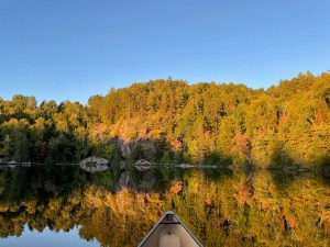
Pinetree Lake
Pinetree Lake is an awesome paddle. It’s really interestingly laid out. Basically, it looks like someone shot a paintball at a wall and decided to use the result as their lake design template. You start off in a smallish bay and paddle west through some narrows. Soon you turn south and paddle through another set of narrows before emerging into a larger space. From here you turn west again and keep paddling until you get to yet another narrows and so on. Essentially, the lake is a large gelatinous blob that’s about halfway through the process of dividing into three or four smaller blobs.


On top of being an interesting lake to paddle, the scenery around Pinetree is spectacular. The shoreline is rocky; rising and falling to various heights as you work your way across. In some places the background hills slope gradually up from the shore. In others, the water ends at decent sized walls. The rockiness extends below the waterline, and as a result the water you’re paddling through is beautifully clear. The bottom of the lake is visible in spots looks a lot closer than it is, which I realized when I tried to plant my paddle on a rock that looked to be a couple feet below us and didn’t come close to reaching it.
In other, significantly fewer, words, Pinetree Lake is pretty.
Our goal for the night was one of Pinetree’s two western sites. Pinetree has three sites in total. The first, and seemingly least exciting of the three, is on the south shore just after you exit the first of the narrows and strikes me as a “well, the sun’s setting and we need to stop somewhere” type of spot. It’d be perfect if I was some kind of hobbit or halfling and I needed a hill for my burrow, less perfect as a human being looking to pitch a tent. The site doesn’t look like it’s got much in the way of flat ground. On top of that, it’s about a five minute paddle from the access point portage and we wanted to stretch our paddling muscles at least a little bit before settling down for the night.


The two sites in the western bay appear much nicer. We ended up on the north shore site. Like the first site, this one is also built on a hill, but there’s enough flat space to set up a couple of tents. Once you’ve got the tents set up, there’s a lot more to like about the site. The views are good. The far end of the bay is dominated by a large rock wall that catches the setting sun just right. The fire pit has a nice view out through dotted pines to the water, and the swimming is great.


It took us less than two hours to get from the parking lot to our site. After dinner, but before the sun had gone down, I took the canoe out for a quick paddle. I headed across to the other side of the lake, then slowly made my way down to the foot of the bay and that large rock wall. The setting sun bathed the rock face in a soft, golden glow. There wasn’t even a hint of a breeze and both the air and water were perfectly still. I floated near the wall enjoying the sense of absolute peace and tranquility surrounding me.
That’s when I saw the Swarmling tree.
Remember how I said there was no breeze? Well, towards the top of the ridge, above the rockface and in the line of trees that topped the rise, there was a solitary tree whose leaves were fluttering like they were caught in a hurricane. I could hear their rustle down on the water and the more I watched it the more disconcerting it seemed. None of the trees around it were stirring. To the left and right the trees were minding their own business, doing what trees on a calm day are supposed to do and standing perfectly still. Meanwhile, the one I was looking at was shaking like it was trying to develop a polaroid picture.
My mind immediately went to the most logical explanation, which was that there was a nest of some kind of heretofore undiscovered eldritch horrors living in that tree, let’s call them Algonquin Swarmlings, who were about to burst forth and attack. I found myself wondering if it would be better to make a break for the woods or simply flip the canoe and use the overturned hull as protection. Then I found myself wondering what I would do if the Swarmlings could swim underwater like some kind of nightmare mermaid. Then I realized it was time to go back to the campsite to sit beside the fire before my imagination (or the Swarmlings) carried me any further away. So that’s what I did.
We passed the rest of the night chatting around the fire and generally enjoying being back in the Park. I went to bed under a beautiful night sky presided over by an almost full moon. It had been a great, if relatively short, first day and I was looking forward to a more challenging day two. Here’s a tip: if you ever find yourself actively wishing for a more challenging next day while on a canoe trip, smack yourself. Maybe twice.
Day Two
Day two dawned pretty much as day one had ended: bright, clear and beautiful. The weather on this trip was outstanding. We had four days of crisp, blue skies, which was a welcome change to what we’d had for our last two September trips. We packed our tents and gear up under a cloudless sky and were back on the water by 9 am.


I was glad for the quick start. This was going to be a big day. Our route was taking us south of Pinetree through a few smaller lakes, before hooking around into Galeairy and over to Rock Lake. We were looking at anywhere between 16 and 24 kilometers of travel depending on where we finally settled, and I was hoping it would end up being closer to the 24 end of the scale so that day three could be a bit shorter.
There was the faintest of breezes pushing the remnants of the morning mist south as we set out on Pinetree. The water alternated between smooth glass and rippling diamond as we navigated Pinetree’s twists and turns toward the portage down to Fraser Lake. Of course, when I say navigated, what I mean is took the scenic route and really got to experience all that Pinetree has to offer thanks to a short side quest (side quest sounds so much more purposeful than wrong turn).


As we paddled the final bay leading up to the portage I spent some time admiring the scenery on the north side of the bay. The shore rises pretty quickly away from the water here, resulting in a high, tree-covered backdrop to the lake. Some of the leaves on the hill had already started to change colour. There were vibrant splashes of red here and there among the evergreens, along with the first hints of orange and yellow as the various maples started to turn. It was very pretty.
You know what wasn’t pretty? The P1825 down to Fraser Lake. Actually, that’s not fair. The portage was very pretty. The forest in that area was lush and green, with lots of variation in the terrain and scenery. Unfortunately, all that’s just another way of saying that the portage was kind of overgrown and had a moderate case of the hills. There were a few downed trees/branches along the path that made things just tricky enough that I was reminded why my canoe squats class is never going to catch on. At one point there was a massive step up on the side of the hill. I have no idea how Gordon and Vince, who were carrying the canoes for this stretch, managed it. I could barely get up with just my pack on my back. But get up I did, and with only a small amount of cursing, and soon enough we had arrived on Fraser.


Sylvia Lake
Before paddling Fraser we made a quick side trip up to Sylvia Lake. Sylvia is accessible by way of a P485 on Fraser’s east side. It’s a dead end lake. Once you’re up there, you’re not going anywhere else (which would be a great tagline for an 80s horror movie). The walk up was quite nice, made even more pleasant by the fact that we’d left our canoes down at Fraser. It turns out that portages aren’t that terrible when the only thing you’re carrying is some residual emotional baggage from the time you watched Backcountry right before going on a canoe trip.
Like Fraser, Sylvia only has one campsite on it. One campsite on a dead end lake at the end of a couple of low maintenance carries? If you’re looking for peace and quiet, Sylvia is the one for you. Of course, if you’re looking for the setting for that 80s horror movie we were just talking about, Sylvia is also the one for you, so maybe you’re better off sticking to Joe Lake. Peace and quiet are overrated.
Fraser Lake
Once we were done admiring Sylvia, we wandered back down to Fraser. I really liked Fraser Lake. It’s not as big as Pinetree, but it’s not small, either. There’s only one campsite on the lake, on top of a rocky ledge on the south shore, and it looks like a great spot to spend a night or two. We paddled past it, then through a picturesque little narrow stretch that was dominated by tall pines and rocky shoreline. As we slid across the water, I noticed that the ripples around us were picking up. We had a slight tailwind, which seemed like the icing on the cake that was our Fraser Lake visit. A small voice somewhere in the back of my mind pointed out that that tailwind seemed to be coming out of the west which might make things interesting on Galeairy, but as with most of the small voices in the back of my head (except the ones telling me to eat more ice cream), I ignored it.


The portage out of Fraser is an 860 meter carry that ends at a small pond in between Fraser and David Thompson Lake. The map shows a low water portage workaround around the pond, but fortunately the water levels were just fine when we arrived. That was a good thing, because for the life of me I couldn’t see where the low water detour started.
David Thompson Lake
We were across the pond fairly quickly, and across the ensuing P220 down to David Thompson Lake just as fast. The portage ends at a boardwalk. The boardwalk crosses a creek-y bit that dominates the lake’s north end. We used the boardwalk as our launching point, which allowed us to experience the joys of trying to turn a 17.6′ boat around in what felt like a 17.5′ space (this is the canoe tripping equivalent of trying to navigate a couch around the corner of a staircase on moving day). Eventually we got our boats pointed in the right direction, and soon we were off and paddling.


Well, we were off and paddling for about three seconds. Then we ran into the large log propped conveniently (for people who like to be inconvenienced) across the mouth of the creek.
Gordon and Mark went to the right around the edge of the log and barely squeaked between it and the creek bank. Vince and I decided to try our luck going left. Five minutes later, once we had gotten ourselves unbeached from the quagmire that surrounds the left side of the log, we followed in Mark and Gordon’s footsteps (er, paddle strokes I guess) and went right.

David Thompson is another lake with just one campsite. Unlike Sylvia or Fraser, I don’t know that this would be a great destination, even if seclusion is your top priority. The lake is basically an overachieving beaver pond. Literally. There’s a massive beaver dam at the south end of the lake which I’m pretty sure is the only reason David Thompson Lake even exists. The water isn’t super clear and it looks like the lily pads are about halfway towards achieving their strategic objective of completely occupying the lake. Swimming here wouldn’t be awesome. The lone site looks okay, but it’s surrounded by damp ground and green stuff. My guess is that the bugs could be horrendous here depending on the time of year. On the plus side, the wet lands across from the site looks like they were tailor made to attract moose, so at least you’ve got the possibility of a cool big animal sighting while you’re fighting off the 30,000 small insect sightings you’re guaranteed to have.
I dunno. David Thompson Lake is fine. Let’s move on.

As I mentioned above, the P1580 down to Galeairy from David Thompson starts beside one of the bigger beaver dams I’ve seen. This thing is probably about five feet tall and has been there long enough that it’s more or less completely overgrown. It was pretty cool. Speaking of overgrown, let’s talk about that portage.
Sigh.
All the portages along this stretch share the same “hey, maybe a weed whacker and a chainsaw once in a while wouldn’t be so bad” vibe. This particular carry probably moreso than the rest. The path was never hard to find, but that didn’t make it easy to follow. There were plenty of spots where the vegetation was encroaching on the trail like a close talker in a crowded bar, or the ground got soft, or something had fallen across the path, or … well, you get the idea. On their own, none of these things are particularly terrible. As a constant stream of minor annoyances, they start to add up. This came to a head near the Galeairy end of the carry where a string of downed trees made it feel like someone was using the portage for a trial run of their new Olympic event, Aggravating Canoe Hurdles. I’m not the world’s biggest fan of Galeairy Lake, but I was absolutely thrilled to see it at the end of that carry.
I was slightly less thrilled about the waves I could see blowing down Mud Bay as I put the boat in the water (The David Thompson portage comes out in a part of Galeairy called Mud Bay that is, on its own, bigger than a whole lot of other lakes in the Park). The waves weren’t terrible, but they weren’t great. I could see the occasional froth of a baby white cap break the surface here and there. The wind wasn’t high enough that I was worried about the safety of going out on the water, but it was high enough that I was already dreading the angry letters I’d be getting from my back and shoulders once we started.

We ate some lunch at the portage put-in and generally postponed the inevitable with the faint hope that maybe the wind would die down while we ate. Sadly, I ran out of procrastination salami before the wind ran out of steam. We turned our canoes into the breeze and started up Mud Bay.
Before we go any further, let’s talk about Galeairy (don’t worry, with that headwind blowing, our team of hardy adventurers won’t get too far without us). I mentioned a few minutes ago that I don’t love Galeairy. Here’s why:
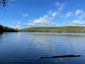
Galeairy is big. Like, really big. I said that Mud Bay is bigger than a lot of Algonquin lakes, right? Well, it’s only about 1/5 of Galeairy’s total area. Maybe not even that much. That’s a lot of lake. And not only is Galeairy big, it’s long. It changes direction a couple of times as you paddle along from Rock Lake to the town of Whitney, and it reminds me of a really wide river more than anything (this is probably because it is a river! Or, at least, it’s part of the Madawaska River system). I’d guess it’s about 13 KM from where we were starting at the Mud Bay portage to the Rock Lake portage. That’s a decent sized paddle.
I’ve paddled most of that distance a few times, and I’ve never enjoyed it. It’s not even the distance that bothers me. In fact, I kinda like long paddles. No, what gets to me about Galeairy is that each time I’ve paddled it, that distance has been accompanied by a full on middle finger from Mother Nature of a headwind.


And that’s why I don’t like Galeairy Lake. Is it unreasonable to dislike an otherwise perfectly nice lake just because it gets windy sometimes? Yes. Do I care? No. Now that we’ve got that out of the way, let’s get back to Mud Bay and see how far we’ve made it.
Hey, you know what? We’ve actually made it pretty far! It turned out that the conditions weren’t that bad to start with. Sure, the wind was there and it wanted you to know it, but we were making decent forward progress pretty much the entire way out of Mud Bay. That changed as we rounded the point across from the town of Whitney and turned west.


See, the wind we were getting on Mud Bay was basically residual wind. The breeze was blowing from the west and, as we were paddling up Mud Bay’s western side, it didn’t have much time to build before it hit us. Once we turned west into Galeairy proper, that wind had had all the time in the world to get excited about seeing us. It’s about a three kilometer straightaway from that point to where Galeairy once again turns north. That means the wind had three wide open and uninterrupted kilometers to build momentum before crashing into us. The result was paddling conditions that sat somewhere between “ugh” and “I wonder how much I can get for this canoe?” on the patented All of Alqonuin Paddling Frustration Index (patent pending).
It took a long time to cover those three kilometers. We were paddling constantly and moving slowly, which isn’t necessarily what you want to accomplish in a canoe. In between strokes I cursed Galeairy in as many languages as I knew how (so, one, but they were very effective curses). Eventually, my incoherent muttering worked and we rounded the corner into a much better protected north/south stretch.

Once we were out of the wind we pulled up on shore for a quick break to unclench our muscles and stretch our legs. We didn’t break too long, as we still had a decent distance to go, but it was nice to be able to put the paddles down without moving backwards. As we stretched and unclenched I looked ahead at the relatively calm water in front of us and hoped the hard part was behind us.
It was! Sort of. The wind wasn’t as bad for the rest of the way. Even once we came out of the north/south stretch and turned west again, it seemed more manageable. This was a good thing, because by this point we were all pretty tired. It had been a long day, both in terms of time and distance. Our goal was the lone campsite on Echo Bay (the first part of Rock Lake after the portage over from Galeairy), assuming it was a decent site. Well, that had been what we told ourselves as we were planning the day that morning. By the time we were paddling that last part of Galeairy (and getting stuck on a random underwater rock shelf in the middle of the lake) I was downgrading my Echo Bay campsite requirement to something closer to “not on fire”. By the time we were crossing the (short, easy) p100* onto Rock Lake, I would have taken that site even if all that was left was a smoking ruin infested with bog dwarfs (so, Furrow Lake).


* The dam in between Rock and Galeairy is a really pretty spot. It’s a man made dam with two areas of flat rock on either side. The view in both directions is quite nice, although it’s probably easier to appreciate if you’re not at the tail end of a 26 KM day.
Echo Bay
Fortunately, the Echo Bay site wasn’t on fire! In fact, it wasn’t a bad little spot. Given that it’s a site on an access point lake with cottages, a campground and paddle in sites, you don’t feel like you’re on one of the busier lakes in the Park. We didn’t see a single group go past while we were there, and the views both east across the bay and west down the narrows towards Rock are quite nice. It also doesn’t seem like it’s a heavily used site. There was a ton of firewood lying around, which made it easy to get a good sized fire going later on.


So, the location is fine, but what about the living arrangements? They’re … okay. There isn’t a ton of flat space. We found spots for our two ground tents, but I wouldn’t call either of them ideal. The spot that was clearly the best tent spot on the site was also directly underneath a widow maker factory. There was a very tall and very dead tree directly over the tent pad with dead branches sticking out in every direction, just waiting for the next stiff breeze. The flat ground was appealing. Being flattened into that ground in the middle of the night, less so.
Once we had our gear set up we made some dinner and settled in for the night. At one point Vince realized that a small point of rocks jutting out from the tip of the site would be a great location for a group shot. Unfortunately, there wasn’t much of a path from the site out to that point. And by not much of a path, I mean there wasn’t a path, period. We bushwhacked through some pretty dense brush to the rocks, racking up a fun assortment of small scrapes and cuts as we went. It was slow going, but eventually we made it.

Once on the rocks we discovered that Vince was right, it was a good spot for a picture. However, to get the shot Vince wanted, he had to set his camera up with a timer on a shelf of rock that was about forty feet away and on the other side of that dense patch of underbrush. This was a complication. See, the max time Vince could set on his timer was 30 seconds. He had timed himself going from the rocks to where he wanted to set up the camera and it had come in at 35 seconds. The question was, would he be able to shave those 5 seconds off the return trip in order to get into the shot?
Silly question.
Vince set the timer and basically became Wolverine at the end of Logan. He ripped through that patch of underbrush like it wasn’t even there. He made it back to the rocks with time to spare and as a result we got an awesome group shot that doesn’t really convey just how much effort went into getting the picture. I’m just glad my eyes weren’t closed. I don’t think reshoots were an option for this one.

Pictures taken and sunset appreciated, we settled in for a night by the fire. The moon that night was spectacular. It wasn’t quite full, but it was close enough. It lit up the nearby sky, drowning out all but the brightest stars. A thin film of patchy clouds had started to move in overhead. They raced across the sky, the moon dimming and brightening but never quite disappearing as they went by. At times, the moon looked like it had a halo, while the outlines of the passing clouds were etched in shadow against the silvery sky. It was beautiful.

Later, long after I had dragged myself into the tent for the night, those clouds brought the only rain of the trip. I woke in the middle of the night to the sound of a gentle rain falling against the fly. I stayed awake for a few minute to see how the fly would hold up. This was the first time I’d had my new Aerial out in the rain and I’ll admit I was a bit worried that it wouldn’t be quite as waterproof as I wanted it to be. Fortunately, I was worried over nothing. The rain stayed where it belonged and I soon fell back asleep to the gentle patter of drops tapping against the outside of the fly.
Day Three
The rain had long since blown itself out by the time morning came around. Day Three dawned a lot like Day Two: bright and clear. Our destination for the day was Fork Lake, a smaller lake just south of Highway 60 that has the notable distinction of being visible from the Visitor’s Center viewing platform. To get to Fork required a bit of paddling, a bit of portaging and a bit of … well, I don’t really know what to call what we did on Rock Creek.
| We started just after 9, pushing off from our site exactly 24 hours to the minute after we pushed off our site on Pinetree the day before (this is not in any way narratively important, I just thought it was cool. Which is the same thing George Lucas said about Jar Jar Binks. He was wrong, I’m not). Echo Bay connects to Rock by a short narrow stretch before you turn north into the wider, eastern half of Rock’s main area. | h | One of my favourite things about canoe tripping is that it turns you into a bit of a Nomad. Every night you build yourself a new temporary home. Then, the next morning, you tear it all down and start again. You don’t know what you’re going to see in between the last tear down and the next set up, but you do know that it’s probably going to be different from what you saw the day before. I love that. |

I’ve paddled Rock quite a few times, but I don’t think I’ve ever paddled up the east side before. It was a pretty paddle. The leaves seemed to be showing more colour by the minute and the rise and fall of the terrain along both sides of the water kept things interesting. The shoreline was, appropriately enough, quite rocky. There were campsites spaced regularly up the east shore, all of which were taken, and quite a few of them looked like they’d be decent spots to spend the night. All in all, it’s a nice enough lake to paddle.

Our next portage, a P1540 over to Gordon Lake, was theoretically an easy portage to find. It’s just the top third of the Booth’s Rock Hiking Trail, so it followed that once we found the trail we’d have found the portage. The slight hitch in that plan was that there wasn’t actually a portage sign down at water level. We paddled up Rock’s eastern shore with an eye out for that little yellow rectangle, but at first didn’t seem to be having any luck finding it. Fortunately, we didn’t end up needing the portage sign. The start of the trail is obvious once you get in close. There’s a wide beach just in front of a parking lot very close to the Rock Lake campground. At the end of that parking lot is a nice big sign that says Booth’s Rock and, in case the well groomed trail disappearing into the forest isn’t glaringly obvious enough, there’s a also a handy yellow arrow pointing the direction you want to go (so, all the things that the Pinetree Lake access point doesn’t have). We shouldered our gear, shooting envious looks at a couple of nearby hikers with their day packs, and set off down the trail.
Man, I wish every portage in the park was the top third of a well groomed hiking trail. This thing was wide, clear and well-maintained. After the low-maintenance adventures of the day before, this one felt like a treat. The distance seemed to melt away and before long we were standing at the grassy put-in on Gordon Lake.
Gordon Lake

This was very exciting. One of the reasons I’d wanted to do this particular loop was so that I could take a picture of Gordon on his namesake lake. In fact, that was pretty much the main reason I wanted to do this loop. Bear that in mind if you’re ever going on a trip where I’m planning the route. Odds are, things like Distance, Difficulty and Darkling Density (the four D’s of any standard canoe trip plan) will take a back seat to whether or not I think a particular destination will be marginally funnier than the rest. While some would argue (by which I mean I would argue) that’s a pretty solid trip planning strategy, it’s probably not going to make it into Kevin Callan’s next book.
Once I’d snapped my pictures we loaded up the boats and set off up Gordon Lake. It was a nice little paddle. There are no campsites on Gordon, but it seems to me that it could support one or two on the eastern shore. I’m sure the Park has its reasons for keeping it camper free, one of which perhaps being that it seems like the moose have already claimed that side of the lake for themselves.
Oh, yeah, we saw a moose! (Or more accurately, Mark saw a moose and I scared it off).
Gordon Lake gets very shallow as you head north, turning into a lily pad choked runway leading to the P600 up to Rock Creek. In other words, it’s basically a five star buffet for moose. Mark and Gordon were ahead of us and Mark was the one who spotted it. Very quietly he and Gordon turned to check it out. Me, being the sensitive and in-touch-with-nature guy that I am, saw them turning and yelled “SEE SOMETHING?”, at which point there was a crashing sound from the forest as the moose threw on its invisibility cloak and disappeared. We hung out in the general vicinity for a few minutes, hoping to see it again, but either it was long gone or it was one of those chamelonmoose you hear so much about these days. Either way, we didn’t see it again.


Gordon Lake ends at a P600 that follows a small creek north. That creek splits off from the larger Rock Creek that is, not surprisingly, about 600 meters to the north of Gordon Lake. This portage was a … well, it was something. Of all the portages we did on this trip, a trip that included multiple truly low-maintenance carries and multiple KM+ carries (per day), I can safely say that this was the most challenging one we crossed.
The Portage That God And Time Forgot
Pretty much the entire carry was overgrown. Which is accurate, but in no way conveys the full hacking your way through Jumanji vibe you got at (many) spots along the way. The portage meandered up and down the side of a small hill for most of its distance. For the most part, the trail (when we could find it) was sandwiched between dense brush and spindly trees that did their best feral cat sharpening its claws impressions on my legs as I passed through. Occasionally we’d come out at a small clearing of overgrown grass and tumbled rocks on the side of the hill. Each time I emerged in one of these clearings I’d look down at my legs and wonder how much blood loss it would take before I started to feel woozy. While the clearings would provide relief from the cheese grater experience, they also provided the opportunity to lose the trail, as it all but disappeared in the tall grass multiple times. Finally, about halfway through the portage, we met our match in the form of a patch of trail that was so narrow and overgrown that the thought of trying to push through it with a canoe on my shoulders seemed like a special kind of stupid. We ended up dropping our packs, grabbing an end of each canoe, and carrying it like a suitcase through the brush to the next clearing.


Rock Creek
After that, things got a bit better. I only remember one more point where I found myself repeatedly ramming my canoe against a wall of branches. Needless to say, I was thrilled when we came out to the large, sloping put-in on Rock Creek. Rock Creek, at least the first part of it, was actually pretty nice. I’d been warned that water levels might be low and I was mentally prepared for a frustrating hour or two. So, you can imagine my surprise, and happiness, as we paddled along the creek and I realized that not only were water levels fine, it was actually a pretty decent paddle. We had to get out and haul over a handful of very solidly constructed beaver dams, but other than that it looked like I’d been worrying over nothing.
I had not been worrying over nothing. As it turns out, Rock Creek is both a name and a description.
In my mind, there are two Rock Creeks. The part below the P55, which is about three quarters of the way to Jean Lake, and the part above. The part below is a pretty standard creek. A few beaver dams, a few twists and turns, nothing too exciting. The part after the P55, so the last quarter before you get to Jean Lake, looks like an alchemist was experimenting with turning water into floating green gunk and ended up with rocks half the time instead.


I lost track of the number of times we were in and out of our boats along this stretch. It seemed like every third paddle stroke we’d ground on a shoal of uneven rock and muck. In many places the water wasn’t even deep enough to drag the canoes upstream without doing serious damage to the hulls. We’d have to unload the boats, put on our packs, work our way slowly upstream along the slippery creek rocks, drop our packs on a patch of dry land near a deep area, go back for the canoes and walk upstream again, hoping that the rock/slime/muck that nearly sent us flying the first time up was somehow less slippery this time around, load the boat, paddle three strokes, scratch the heck out of the bottom of the boat on the next shoal, repeat.
It got old, fast.
By the time we reached the portage over to Jean we were all so resigned to the fact that this endless cycle of low water, slip’n’slide rock hopping was our life now, we almost missed the take out. The creek turns at the portage bank, continuing north through another rock garden. Mark already had his pack on and was dutifully trudging further up the creek when I noticed the portage. I don’t think I’ve ever been as excited to see the start of a portage as I was in that moment. I mean, it wasn’t as if it was that different from what we were already doing, but at least it meant that the creek was finally behind us.
Jean Lake
Jean Lake, which was at the other end of that surprisingly long feeling P325, was fine. I’m not going to lie, I don’t remember much about it. I guess I was just lost in the delirious joy of being off Rock Creek. So here’s a picture, instead:

I do, however, remember the last portage of the day, the P335 from Jean over to Fork. Why do I remember it? Because the entire Godd*mned thing was uphill. Well, except for the last hundred meters which is basically a double black diamond ski slope. I’m not sure whether going up or coming down was worse. I do know that I got to the end, dropped my boat in the water, and said a whole bunch of things that can’t be repeated in a family friendly blog.
Fork Lake
But you know what? It didn’t matter! Because that was it. The last portage of the day. We were on Fork Lake, we had our pick of the two sites on the lake and we still had a ton of afternoon in front of us to rest and relax. No more portages, no more beaver da … wait, is that a massive beaver dam cutting off the portage bay from the rest of Fork Lake?
Sigh.
Fine. No more portages, one more beaver dam.
Once we had that final dam in our rearview mirror, it was a quick paddle to check out Fork’s sites. Of the two, the island site is clearly the better option. It’s a big space, with great views, lots of room for tents, decent swimming and it gets great afternoon sun. The other site, a small hole in the woods on the mainland just north of the island, is perfectly serviceable, but not in any way memorable. It’s small, enclosed and feels just a bit like it might be a secondary location for The Cultists of Sylvia Lake. The only thing it has going for it over the island is that it is much more protected from the elements. That island spot is pretty exposed. Staying there in the early spring or late fall could get pretty cold if a stiff breeze were to pass through.


Fortunately, we were there on a sunny day in the early fall and it was great. Once we had ourselves set up for the night, Gordon and I made a quick trip over to Norway Lake (which involved pulling the canoe over yet another beaver dam smack in the middle of the narrows between the two lakes). Fork and Norway are both nice enough little lakes. I’d probably put Fork ahead of Norway, but not by a lot. One interesting thing about Fork is that from parts of the lake you’ve got a clear view of the Visitor’s Center (and the Visitor’s Center has a clear view of you). You can’t see it from either of the sites, which is nice, but you do get the occasional bit of highway traffic noise wafting across the water.
Once we were back on Fork we gathered some firewood from along the shore and paddled back to the site to relax away the rest of the day.

I have to say, that site is a great place to get some serious relaxing done. The swimming is good, there are plenty of trees to hang hammocks from and the setting sun absolutely baked the west side of the island. The temperature differential between the fire pit area, which faces south east, and the swimming/sunset watching area felt like it was about ten degrees. I was comfortable in shorts and a t-shirt while I was cooking dinner on the site’s western rocks, but I needed long pants, a long shirt and a toque pretty much as soon as I moved over to the fire pit. Vince, who must be part Yeti, stayed in shorts until after the sun had gone down, while the rest of us had long since layered up in pretty much every piece of warm clothing that we had.

It got cold overnight. Much colder than the two nights previous. I had a lighter sleeping bag with me and, despite wearing my warm clothing to bed, I hovered just on the edge of being too cold for most of the night. Still, it was another beautiful night. The moon was bright, the sky was full of stars and I fell asleep to the sound of the waves lapping against the rocks (and the occasional rumble of a truck passing on Highway 60).
Day Four
We woke the next morning to a wall of mist. It was like a cloud had decided it liked the looks of Fork as well and decided to spend the night. Thick tendrils blew across the island from the south, and to our west the far shore was completely hidden behind an opaque mass of low flying cotton candy. It took a while, but eventually the sun got high enough above the eastern trees to burn it all off. By the time we were packed up and ready to go, it had turned into another perfect day.


| This was our last day, and it was meant to be a relatively short one. It’s just under 9 KM from Fork Lake to the Pinetree parking lot. However, 4.4 of those kilometers are spread out among three portages, two of which are low maintenance and seemingly all of which are uphill, so we weren’t exactly looking at a Little Doe to Canoe type of out day*. The paddle from our site on Fork to the first portage was a grueling 20 or so seconds, and then we were back on dry land and headed up to Rose Lake. | h | *Little Doe to Canoe Lake is about 9 KM and is on one of the Park’s most travelled routes. There’s only one portage along the way, a P300 that’s probably the easiest carry in the Park. In my head, this is the litmus test for an easy out day, but that’s not exactly fair. You’re covering a lot of water going from Little Doe to Canoe, and if the wind is working against you it’s a slog, particularly going down Canoe. Long digression short, any route in the Park can be challenging given the right conditions. |

Apart from it being a stubbornly uphill carry almost the entire way, there’s not much that stands out in my mind about the P1550 up to Rose. What does stand out is Rose itself. Man, that’s a pretty little lake. It’s divided into two bays that look quasi symmetrical on the map (if you’re willing to stretch the rules around your definition of symmetrical). You start at the north east tip of one half, then round a small point and head down to the south part of the other half to the next portage. The shoreline is rocky in places, with patches of denser underbrush interspersed with more open areas. There are a couple of spots that look like they’d made for a good campsite, but there are no sites on Rose. Which is a shame.
When we arrived the water was flat, the sun was bright and the air felt crisp. As we paddled round that point and into the southeast bay, we passed by a smaller bay presided over by a small island and a tall pine tree leaning out over the water. The sun was climbing a perfectly blue wall of sky in the background, giving the entire bay a warm looking glow.
It was a perfect moment.
I stopped paddling and tried to take everything in. We drifted for a few minutes while Mark and Gordon caught up. I knew that this was my last significant trip of the year and I wanted to try and imprint the memory of that moment so I’d have something to think back on in early January when I’m digging out my driveway for the fifth time in four days. Hopefully Future Drew appreciates the effort. Even if he doesn’t, it made for a very nice few minutes for Present Drew.
In my mind, the P915 from Rose up to Pinetree was somehow worse than the longer one from Fork to Rose that we’d just finished. I’m not sure why that’s the case. When I look through my photos from that portage all I have are a shot of Vince starting off with the canoe and a short video of a cool little stream hidden at the bottom of a gully full of moss covered rocks that cuts across the trail at about the halfway point. Not carrying the canoe and a cool water feature? These are like A and B on my “what makes a good portage” checklist (C is “no zombies, Blair Witches or other 100% real and not imaginary terrors).


I think what got me about this one was the very end, just before you reach Pinetree Lake, where there’s what feels like a completely unnecessary uphill. It comes out of left field (or left forest, I suppose) and it happens after you’ve seen the patch of blue that tells you you’re almost done. That’s just not fair. As The Law of Conservation of Portage Matter states: “Portages can be neither created nor destroyed, they just change shape. Except after you’ve seen the blue. Once you’ve seen the blue the thing is done and there’s no more uphill. Anything else is b*llsh*t”.
Pinetree Lake (Again)

And just like that we were back on Pinetree, the lake we’d started from three days earlier. The paddle along Pinetree back to the final portage up to the parking lot was just as nice as the paddle down the lake had been at the start of the trip. Of all the lakes we saw on this route, I think Pinetree is by far my favourite. The combination of the clear water, rocky shoreline, many distinct areas and generally gorgeous scenery make for a fantastic paddle. I would happily go back, whether as part of a longer trip or even just as a spot to settle in for a couple of nights.
We took a few minutes at the start of the portage to soak in the moment and snap a couple of pictures. Among others, we got a group shot that is hands down one of my favourite group shots ever. It looks like an album cover from a moderately successful 70’s folk rock band. Like if Bread was into canoe tripping. After that, all that was left was the portage back up to the parking lot.

Ugh.

For whatever reason, I felt that last portage. I think part of the problem was that I had mentally finished with the trip when we pulled up at the end of the Pinetree paddle. As far as my legs were concerned, I was back at the access point. Unfortunately, as far reality was concerned, I still had two KM of uphill carrying to deal with. As is usually the case, reality had the final say and we worked our way back up to the parking lot (Mark was a beast on this carry. He took the boat and just started walking. Meanwhile, I was passing my boat off at every opportunity like I was playing the world’s most cumbersome game of hot potato).
After what felt like much longer than it needed to be, I stumbled back into the lot and dropped the canoe beside the cars. I was happy to be done the carry and even happier that both Gordon and Mark had giant bags of Doritos waiting in their car. I learn an important lesson every trip, and this time was no exception. Always, ALWAYS, have a bag of Doritios waiting in your car. Orange dye # 28 has never tasted so good.
And that was it. Trip over. I’m sad already.
I loved this trip. We couldn’t have asked for better weather or conditions. The route was challenging, but fun. I wouldn’t have minded if there had been even one day without a KM+ portage, but for a portage heavy route it wasn’t all that bad. Meanwhile, off the portages, the scenery was awesome. The fall colours were just starting to show and the rockiness of the area made for an absolutely gorgeous backdrop for paddling. I loved Pinetree Lake in particular, but don’t sleep on Fraser, Sylvia or Fork either (or, more accurately, do sleep on them). They’re all really nice spots with great scenery and decent to great sites.
Time to start planning for next year.
284 Down. 248 To Go.
New Lakes: 9
Total Lakes: 12
Total Portages: 15
Total Portage Distance: 14.41 KM
Total Travel Distance: 60 KM
I loved your trip report!! I kept reading parts out loud to my husband… so entertaining and well written. Pinetree is one of my favourite lakes to visit for a few nights of “interior camping.” I have explored the shoreline many times and appreciated your insights. On the first campsite from the Pinetree portage there is a hike to a beautiful creek that you can follow into Bud Lake. The other fun day trip is a bushwhack up the ridge to the Leaf Lake Ski trails. Lots of good hiking to very impressive lookouts. We live in Whitney and sometimes will paddle Mud Bay and walk the portage into David Thompson. I am always glad I am not carrying more than my lunch. Anyway, really enjoyed hearing about the lesser known lakes and portages. Terrific Read. thanks!!
Thanks Tess!
Thanks for this. Doing a day trip there and looking for something to do once I get there.
The author’s vivid descriptions paint a vivid picture in the mind, making you feel as though you are right there, immersed in the tranquil surroundings of Pinetree Lake. The article not only showcases the beauty of the area but also provides valuable information about the trail, ensuring that readers can fully appreciate and plan their own adventures. The attention to detail and the passion conveyed in every sentence make this article a true delight to read. It’s refreshing to come across such engaging and informative content that celebrates the beauty of our natural world. Kudos to the author for crafting such an exceptional piece that inspires and ignites a sense of wanderlust in readers!
Thank you very much for the kind words Chris. Glad you liked it!