Blue-green algae is no joke. Also known as cyanobacteria, blue-green algae is a micro-organism that lives in lakes, rivers and ponds, and it can be a serious health hazard if it gets out of control. The thing about water contaminated with blue-green algae is that you can’t really treat it. At least, not with conventional methods you might use on a canoe trip. You can’t filter it out, you can’t use tablets to kill it. You sure can’t boil it; that actually makes it more dangerous. And what happens if you drink it? Nothing good. Headache, fever, liver damage and stomach issues are just some of the symptoms. Heck, just getting some on your skin can lead to rashes, swelling and other irritations. In short, it’ll make a human very sick (and it can kill your pets).
So, why the science lesson?

Unfortunately, blue-green algae isn’t unknown in Algonquin. Over the past few years there have been a few lakes around the Park that have experienced blooms . Dickson Lake, just east of Opeongo, was one of these lakes (and St. Francis Lake, near Achray, potentially has one right now). The Park discovered a bloom on Dickson back in 2015 and closed it to camping. It stayed that way for the next six summers. This closure coincided with my getting back into tripping. My 100 Lakes summer was 2016, meaning that for the bulk of my recent tripping time Dickson has been closed.
Over the years, Dickson took on an almost mythic status in mind. As each summer came and went without it reopening I became more convinced that it never would. I had it in my head that it was a lost gem; this beautiful spot that was going to be forever off limits to anyone who didn’t want to experience *squints* swelling of the lips, diarrhea and abdominal cramps. Gross. So, as you might imagine, I was thrilled when the Park announced that Dickson would reopen for the 2021 season. Not thrilled enough to book a trip through it right away (I feel like drinking from a former toxic algae hotspot is not a thing I need to be the first to do) but it was great knowing that I would eventually be able to visit it.
That visit finally came this past Labour Day, at the tail end of a four day, three night loop out of Opeongo. Was Dickson worth the wait? … I mean, I can’t answer that yet can I? That’d be giving away the ending. Like telling you that Bruce Willis was actually *redacted* the whole time or that Kevin Spacey was actually *redacted redacted redacted* in the *redacted*. It just wouldn’t be fair. So let’s read on and try to ignore the fact that I just set expectations for this trip report alongside two of the greatest movie twists of all time.

We were running late. We’d been later leaving Ottawa than expected, and our two pit stops along the way both took longer than they should have. As a result we pulled up to the Opeongo access point about ten minutes before our scheduled water taxi. This wasn’t ideal. AO, quite reasonably, asks you to be at the access point at least half an hour before your ride. You need to get your gear sorted, go through the paperwork, park your vehicle and generally do a bunch of stuff that will likely take longer than ten minutes. However, since we weren’t the only ones waiting on our taxi (there was another group heading in to Happy Isle in the same boat) we didn’t have much choice but to get everything unloaded on fast forward and hope nothing got forgotten in the rush.
 We somehow got it all done: canoe unloaded, gear stacked by the boat, paperwork signed, car parked in the upper lot, with about a minute to spare. I may have sprinted down from the parking lot to make it under the wire, but I did it. Except, while I had made it down from the parking lot, it turned out my phone hadn’t. Even better, I knew for a fact that I’d started the run down from the parking lot with my phone in my back pocket, so it wasn’t like it was back in the car. I’d dropped it somewhere along the way, and I had no idea what route I’d taken as I ran through the two crowded lots.
You know what’s fun? Realizing that you have to turn around and sprint up the hill you just ran down, and that you have no idea where the thing you’re missing may have dropped, so you can’t even properly retrace your steps. On the plus side, who doesn’t love a chance to run a few stairs before starting a canoe trip?
Fortunately, it turned out that my phone had popped out of my pocket at the base of the stairs up to the upper lot. Thank God. I’d been oscillating between thinking I’d never find it or that I would find it, but not before someone else’s tires did. Breathing a sigh of relief (that sounded less like a sigh and more like a panicked gulp of air as my lungs caught up to my legs) I picked up the phone, put it into my zipped pocket, and sprinted back down to the water taxi.

With that bit of excitement behind us we were ready to get underway. You know what’s actually fun? Not fake fun like phone induced wind sprints? Water taxis. Water taxis are fun. Man, do those things move. The AO taxis have 225 horsepower engines on them and they absolutely eat up the lake. A couple weeks earlier it had taken my brother-in-law and I two and a half hours to paddle up to the north end of Opeongo. It took the taxi about 10 minutes to cover the same distance. In no time at all the driver had us at the start of the Proulx portage, canoe unloaded and ready to start.

The route up to Proulx is either a P175 and a P965 broken up by a paddle across a small pond, or an uninterrupted P1395 if you decided to just carry around the pond. I had started off carrying the boat and I went with option two as it seemed like less hassle than having to load up the canoe just to unload after a hundred meters of paddling. Also, the portage around the pond doubles as a cart trail, so it’s not exactly a challenging carry.
Despite the easy trail, it was still a kilometer plus of hiking with a canoe on my shoulders and I was definitely feeling it by the end of the portage. Proulx was a sight for sore eyes (and shoulders), although the waves rolling north across it were less exciting.

As I mentioned already, this was a three man trip. Which meant we were stuffing all three of us, and our gear, into my Swift Winisk. We somehow made everything, and everyone, fit and set off across Proulx, hoping the waves lapping at our gunnels didn’t get too much higher (I didn’t know if I was the Butcher, the Baker or the Candlestick Maker but I did know that if those waves got much bigger there was a better than even chance Mark, Vince and I would be channeling Mother Goose’s favourite communal bathers).

The sketchiest moment came as we rounded the point into Proulx’s north arm. The waves were bigger here, and a couple of them spilled over the sides as we tried to swing the boat around. There was a brief wobble, and a very unwelcome couple of centimeters of water beneath my knees, but we managed to keep things balanced. Soon we had some shoreline between us and the worst of the wind and the paddle north got a bit easier.
I’m not sure what to say about Proulx. It’s a big lake, but I don’t find it all that appealing despite the fact that I usually love bigger lakes. I think part of it might be that none of the campsites we paddled past looked all that great. Most are just holes in the shoreline. That type of site is fine for a stopover if you’ve had a long day and are just looking for a place to crash, but I wouldn’t want to make it a multi-day destination.
It took a bit longer to get through Proulx than it would have on a calm day. I decided to hug the western shore to try and cut the wind. This made for less of a tightrope feeling paddle than the first part of Proulx, but also added some extra strokes. Even so, it wasn’t long before we were at the north end of the lake and paddling into the narrows that hides the mouth of the Crow River.


The wind hadn’t died down while we were on the river, we’d just been protected from it. Once we were back on open water you could tell it was going to be a factor again. It was coming from the west and pushing a steady army of small waves in front of it.
Little Crow itself wasn’t too bad. It’s not a terribly big lake, which means that the wind doesn’t have a ton of distance to pick up speed over when it’s coming from the west. There are only three sites on Little Crow, all of which are on the east shore and all of which look fine, if unspectacular. We were through Little Crow in good time, and through the narrows connecting to Big Crow just as quickly.

The wind was worse on Big Crow. Even coming from the west, the most protected part of the lake, the breeze was strong and the waves were noticeable. As we paddled eastwards across the bottom half of the lake, the wind got stronger and waves bigger. Fortunately, both the wind and the waves were behind us, and neither were strong enough to be a safety hazard. If anything, they actually gave us a hand, pushing us towards the eastern shore at a steady clip.
That steady clip was important. Big Crow was busy, and we were in a race.

See, the first three sites we saw as we entered Big Crow were taken and I was worried about what that might mean for us. I knew that the lake was booked out, and I wasn’t looking forward to potentially having to paddle up to the top of the lake to find the only empty site available. As those thoughts were skittering through my mind, we came round the point just north of the Big Crow ranger cabin and saw a wide open beach site nestled on the eastern shore, just beside the opening to the continuation of the Crow River that we’d be using the next day. In other words, it was perfect.
Except, we weren’t the only ones who thought so.

As we started towards the site we saw another canoe coming from the north. It was following the western shore but as I watched, it turned and headed in the same direction we were going. While there are actually two sites close to each other on that shore, and both were empty, the one we were headed towards was clearly the better. Vince and I poured it on and pretty soon it became clear that we were going to make it to the site first.
The victory was sweet, for about five seconds. At which point I took a good look at the canoe we’d just beaten and realized we’d been racing a family of four. In tough conditions. To a site that, as it turns out, was tailor made for kids.
Want to feel like a complete jackass? This is a pretty good way to accomplish that.

To make matters worse, the other canoe had already turned around and was pushing against the wind back towards the western shore (where there was an open site further down towards the ranger cabin). I don’t know if they didn’t know about the second site, or just didn’t want to be too close to the group of jerks who stole their site, but whichever it was, they weren’t looking back. We tried to wave them down so we could offer them the beach site and take the one just a bit further north, but they either didn’t see us or thought we were doing the Algonquin Park equivalent of drinking Aaron Rodger’s Ayahuasca. They were gone. And we were on a great site that came complete with a beautiful beach, a spectacular sunset and absolute boatloads of guilt.
 We passed the rest of the evening alternately swimming, exploring and enjoying the sunset. The swimming, in particular, was awesome. That part of Big Crow is super shallow. The lakebed is soft sand, and it goes on forever. Mark and I both waded out at least 150 meters from shore, and the water was barely up to our chests even that far away. It made for a really nice spot to swim, and the western sun beating down combined with the still strong oncoming wind felt like an industrial air dryer when it was time to get out.
We watched the sun set while we ate our dinners, then watched the stars come out while we sat by the fire. Later, when the moon was above the southern tree line and the stars everywhere else were bright, we wandered back down to the water. The stars meandered slowly across the sky, punctuated occasionally by a streak of light as something that should have shifted its orbit just a bit higher burned up in the atmosphere. It wasn’t awful.

Not long after we turned in. The next day promised to be a longer one. We were paddling the Crow River over to Lavielle, and after my run in with the Upper Nipissing earlier in the summer I was already having night terrors about how low the water levels might be.

We woke up reasonably early and were off the site in good time. It was a beautiful morning. The weather report was calling for some rain at some point that day, but you wouldn’t have guessed it from the blue skies and bright sun.
 There are 7 portages along the Crow River between Big Crow and Crow Bay and, as it turned out, a couple of spots where the water levels are just high enough to make it look like you might be able to paddle through, even though you most certainly cannot. In other words, unlike the day before, where once we were in the canoe on Proulx we stayed in the canoe until we got to our campsite, this day was going to bring quite a few opportunities to get in and out of the boat.
I took the middle seat for the first leg of our paddle. I did not love the middle seat. See, the way we made everything fit meant that whoever was in the middle had to sit on the bottom of the boat with their legs splayed up and over the yoke in front of them like they were about to give birth. It wasn’t the most comfortable position. My back had plenty of thoughts about being folded up like a card table, and none of them were polite. On the plus side, the awkward positioning meant that the person in the middle wasn’t paddling and could simply sightsee as they were carried along, which is exactly what I planned to do as we paddled away from our site and into the mouth of the Crow River.

The first leg of the river, a 2-3 KM stretch from Big Crow to the first portage, is relatively wide and quite pretty. After that first portage (an easy P240), the next stretch was still pretty, but narrower and shallower. Almost immediately after putting in we came up against a downed log and a couple of large rocks just below the surface that we couldn’t paddle around. Mark and I hopped out of the canoe to move the boat while Vince, who had drawn the middle seat straw, monitored our progress from the bottom of the boat. I will say, if there was a segment to be in the middle seat, this was it. That first blockage was just the start. We were in and out quite a few times, dragging over shallow spots, navigating around rockbergs just below the surface and redirecting the boat when the current was pushing us just a bit too hard into an obstacle. Fortunately, none of the shallow areas were too long or too challenging, and it was actually kind of fun walking through the ankle deep river with Vince drifting ahead.


Before long we were at the only longer portage of the day, a P1220 that finished off the first third of the river. This was a nice portage, flat, easy to follow and in good shape. It was made nicer by the fact that Vince took the boat for the entire carry. In case anyone out there is wondering, not carrying the boat on a portage > carrying the boat on a portage.

Once we were over that portage we were looking at the longest stretch of paddling we’d be doing along the river. There’s about five KM of river between that P1220 and the next portage, a much shorter P385. This part of the river had a bit more back and forth than the parts we’d already paddled, but not so much that it got tedious. While some clouds had started to roll in, it was still a beautiful morning and I really enjoyed the vibe along this stretch of the Crow.
At about the halfway point between the two portages is the Crow River’s lone campsite. We stopped here to check it out and so we could switch out the middle seat (it was my turn to sit in the quarter inch of water that was a permanent fixture in the bottom of the boat). This was a decent site. While I don’t love camping on rivers, something that was driven home quite clearly on my Nipissing trip earlier this summer, I could make an exception for this site. It’s a big site, with a nice fire pit and a great view up and down the river thanks to its perch at the top of a short hill. The swimming wouldn’t be great, the river is narrow and not that deep, but otherwise it would be a decent spot to stop for the night.


I actually dozed off a bit once we got back in the boat. The sun was out again, the air was stuffy and it seemed like the day was begging me to take a nap. I mean, what else is a middle seat guy going to do?

There wasn’t anything in particular that stood out to me about the final third of the river. Once we had finished with my nap leg, we were back into smaller segments separated by short portages. We stopped for lunch at the bottom of the P170 (which was an absolutely gorgeous rocky narrows with waves and ripples that sparkled in the sunlight) and experienced our only bit of rain a few kilometers later when a passing cloud dropped just enough water to cool the day off. By that point, we were done with the last of the portages and wending our way towards the end of the river and out into Crow Bay.


Crow Bay is big! Honestly, I feel like it should be its own lake. In fact, why isn’t it its own lake? There are plenty of smaller lakes in the Park. What exactly does South Canisbay Lake have over the Algonquin Park Lake Naming Committee that it gets to be a lake while Crow Bay, which is roughly seventy zillion times bigger and doesn’t qualify as the definition of a quagmire, doesn’t? Some day, when the congressional investigations into the APLNC are complete, maybe we’ll have some answers. Until then, we’ll just leave it at Crow Bay is big and it’s beautiful and it deserves better.

We stopped briefly at the first site on Crow Bay’s south shore to filter some water and stretch our legs (nice site, would be a great spot to stop overnight if you were coming or going on the river). Once the water was filtered and our legs were stretched we set off across Crow Bay for Lavielle.
We had the wind at our back as we paddled east. It was a decent breeze, pushing us and the waves ahead of it as it went. Mark and I were paddling and we decided to see how fast we could get our tub moving with help of the wind. We got up to 8.8KM/hour, which felt like an accomplishment given the weight inside the canoe. Of course, once we stopped paddling the boat didn’t slow all that much, so maybe it’s less impressive than I want it to be.


Crow Bay is split into two parts by a short narrows. Most of the sites on the Bay are on the eastern side of that narrows, and they all looked pretty decent. With the benefit of hindsight I would probably book Crow Bay over Lavielle for a similar trip if only to more evenly split up the days and because the sites seem so nice (also, Crow Bay is really pretty!). However, this time around we were booked on Lavielle, so we kept on paddling. Soon we were moving past a pretty island at the eastern end of the Bay and through another narrows and then the water opened up again and we were on Lavielle.
Remember how I said Crow Bay was big? It’s got nothing on Lake Lavielle. You could fit Crow Bay into the top third of Lavielle a couple of times and still have room to spare. We came out from the narrows and were greeted with an absolutely enormous expanse of water heading east. And that water was not calm.
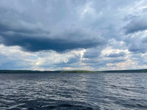
The weather had steadily deteriorated as we finished the Crow River and passed through Crow Bay. By the time we arrived on Lavielle there were thick, dark rain clouds to the north and the wind was blowing hard. We could see sheets of rain blanketing the north shore, and it seemed like only a matter of time before that rain migrated south. My original hope had been to paddle across Lavielle and stay on one of the island sites near Crow Island in the northeast part of the lake. One look at the baby whitecaps marching away from us towards that island pushed that plan overboard. Instead, we decided to turn south and hug the western shore. There were fewer campsite opportunities this way, but that seemed like a reasonable trade off in exchange for fewer capsizing opportunities.
 As we were setting up on Big Crow the night before we’d discussed exactly how much bad site karma we might have accrued thanks to our race. A lot, as it turns out. And the universe wasn’t taking any time in letting us know it. While the site we had picked on Lavielle would be decent enough (probably even quite nice) on a calm day, this was not a calm day. The wind had shifted as we were unloading and was now blowing directly through the site. And it wasn’t getting any weaker. If anything, it seemed to be picking up strength. The net result was one of the colder evenings I’ve spent in the Park. The fire, which Vince had roaring, threw off a decent amount of heat, but that heat seemed to be being blown out the back of the site before it could get to me.


It wasn’t all bad though! This particular site was made for swimming. It’s got a couple of beautiful rocky slabs where you can slip in, including a smooth slope facing east that would be wide enough to use as a boat launch if you wanted. There are a couple of smaller islands nearby that would be perfect to swim to (again, on a calmer day) and that boat launch slope is an awesome place to eat dinner and watch Lavielle (or, in my case, eat an Alpinaire rehydrated chocolate mudslide and watch my blood sugar numbers spike straight past unreasonable to espresso drinking hummingbird levels).
At one point, somewhere between dinner and the sugar avalanche that was my dessert, Vince decided to explore the island. He came back about an hour later with the news that there was another, better, significantly calmer, site on the other side of our (very small) island. This was odd, as my (admittedly out of date) map didn’t show a site there (and as we discovered the next morning, the site isn’t marked with a sign or in any way visible from the water). But it was definitely a site, complete with fire pit, benches and a thunderbox. We stayed put, taking everything down seemed like too much of a hassle, but I’m curious about this site. I checked the most recent official Park map and it’s not listed there. It’s definitely been used, however, and I wonder if it’s something the Park keeps aside for staff to use while they’re in the area (and that has me wondering if there are unmarked sites like this one scattered across Algonquin). Whatever the explanation, it was a cool find (and if anyone reading this can fill in the blanks, please do!).

The wind blew steadily throughout the night. I woke up a couple of times, and each time I was greeted by the sound of trees creaking and leaves rustling. I rolled out of the tent at around 7:30 and found a grey blanketed sky and a never ending procession of waves rolling in from the east. This was problematic as we were heading south, and we were going to have to cross a decent amount of wide open water (Thomas Bay is big enough to be its own lake, and we were paddling across the top of it). In other words, we were looking at crossing Lavielle in an overloaded canoe, broadside to the oncoming wind and waves. Not ideal.

We took our time getting packed up in the hopes that the wind would die down. We explored the island, checked out the secret site and slowly came to the realization that the wind wasn’t going anywhere. Finally, at around 10:30, we found ourselves standing on the eastern end of the island, staring out at the waves and realizing we’d run out of ways to procrastinate.

We decided we’d paddle around our island and use the western edge as a starting point. This gave us some protection from the wind to get started, and let us take a somewhat more head on approach to the wind. Basically, instead of paddling sideways to the waves we were paddling diagonally. It was an improvement. Sort of.
That was a tense paddle. If the wind had been any worse we probably would have had to stay put, but it was just manageable enough that I knew we could make it as long as we were careful. And we were careful, communicating any movements and keeping focused on the water. Even so, there were quite a few rollers that came over the bow. Still, we made it. After what felt like an hour but was really only about 15 minutes, we arrived in the lea of a small island on the other side of Thomas Bay.


We took a couple of minutes to appreciate not having gone for an unexpected swim in the middle of Lavielle, then continued on.
While the wind was still a factor after that crossing, it was nowhere near as strong. Lavielle narrows as you head south, meaning there’s less time for the waves to build up. From the end of Thomas bay onwards it was a much more usual type of paddle. At one point Mark and I switched spots (he’d had the middle seat for the paddle across Thomas and all the wet pants fun that came with adding a few waves worth of water to the bottom of the boat). This meant that I got to take it easy as the other two took us down through the south end of Lavielle and into Hardy Bay.


I really liked this part of Lavielle. There are a few sites to stay on, and the scenery was quite pretty. It’s a bit more enclosed than the main part of the lake, meaning wind is less of a factor. That said, if I were to stay on Lavielle again I’d probably still try and grab one of those sites up near Crow Island. Something about that part of the map looks very appealing.
About an hour and a half after we’d left the campsite, we arrived at our only portage of the day, a P90 down to Dickson. We didn’t even bother to flip the canoe up for the carry. Instead, Mark and I suitcase carried it across before going back for our bags. I also stopped to check out the small creek that the portage follows and which connects Dickson to Lavielle. It’s a pretty little spot. The sound of the water rushing over the rocks filled the air and the sun sparkled in the ripples.


Dickson itself was quite pretty as well. The sun was out and the wind wasn’t as strong as we paddled south. Dickson is dotted with a few small islands, and home to a few provincially significant forests. It’s got a wild feeling to it, part of which may be due to the fact that it was closed to camping for the better part of the decade.
We didn’t have a particular site in mind, although it would have been cool to stay on the east shore site smack in the middle of an old growth forest, so we meandered south, hoping to find something decent. One thing I did notice as we went was that my map was out of date as far as campsite locations went. I’m using the most recent version of Jeff’s Algonquin Map, but by this point it’s been quite a few years since it was updated. For example, the two island sites in the north part of Dickson weren’t where we expected them to be, although there were sites on those islands. I wonder if the Park used Dickson’s closure as an opportunity to move things around.

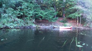
Regardless, the sites we saw in the north were taken, as was the site in the old growth forest on the east shore. We kept going until we arrived at the island site directly across from the P5470 (gulp) over to Bonfield Lake (and our route for the next day). This site was open, and it was awesome.
This is a huge site, with lots of room for tents and a decently protected fire pit area. It’s also got a great north facing beach for swimming and pulling the canoe up. But the best features of this site, by far, are the views. If you go to the westward tip of the island there’s a small stone beach that wraps around the end of the island. From here you’ve got a 270 degree view south, west and north. It’s a perfect spot to watch the sun go down, which is exactly what we did later that evening.


But that, however, would have to wait. We still had a decent amount of day in front of us. We got the site set up then Mark and I did a quick side trip up to Little Crooked Lake while Vince stayed back and made sure we’d have enough fire wood for the night.
The portage over to Little Crooked is out of the north east corner of Dickson. The shoreline here is dominated by a beautiful beach that wraps around most of the portage bay. It’s a gorgeous spot to start a portage, which is more than I can say for the rest of that carry.

The Little Crooked portage is a P1100 that lives up to its low maintenance billing. The path is followable, but it’s not great. It’s also one of the more technical portages I’ve done this year, in that at various times you’re walking along the side of a hill that is just desperately trying to roll your ankle, hopping from rock to rock through wide patches of mud or stepping over, on and around various obstacles. Also, the last 50 meters leading into Little Crooked is swamp. On top of that swamp the Park has laid out a series of logs, cut to size and placed side by side. Normally this would be more than enough. Unfortunately, at least when we were there, most of those logs were free floating, meaning that as soon as you stepped on one you’d sink into the swamp. It turns out that hopping from unsteady log to unsteady log while your shoes slowly fill with enough ooze to mutate some baby turtles is not an ideal way to end a portage. Mark, showing a great deal of good sense, hung back, leaving me to complete the Little Crooked hopscotch spectacular. Which I did!


Little Crooked was … it seemed fine I guess? There are two sites on it, so if you’re looking for some privacy this wouldn’t be a bad spot. But, to be honest, I don’t think it would be worth that portage. I took a couple of minutes to appreciate my (very likely only) visit to Little Crooked, then we turned and headed back the way we came.
The rest of the day passed quietly. I took a swim once we got back to the site and made some dinner, but mostly I just sat at that western tip spot, watching the water and enjoying my last night in the Park.
 The sunset that night was spectacular. There was a mat of cloud just to the south west. It wasn’t enough to block the sun, but it sure caught the sun’s rays as it went down. The sky started off clear and blue, then slowly faded to a mix of soft pinks and oranges. Every time I thought it couldn’t possibly get any better, it did. Along with the light show, there were a couple of loons working their way around Dickson, their calls echoing out over the flat water.
Once the sun had dipped behind the western shore we started thinking about the night’s fire. It was right about then that I noticed a canoe coming from the direction of the Bonfield/Dickson portage. At first I thought it must just be someone out for an evening paddle, but as I watched I realized that they weren’t returning to a site, they were looking for one. They started towards our island, but must have seen us sitting there because they shifted their heading pretty quickly and pointed north. I watched them paddle out of sight into the north end as the sky turned grey and dusk settled in. I have no idea where they ended up, but I felt for them. There’s nothing worse than paddling around a large lake, racing the sun and trying to find a campsite. That said, they had passed up a couple of open sites coming out of the portage bay, so I guess they couldn’t have been feeling too urgent about it.

The rest of the night passed quickly. It was cool. The temperatures were dipping into the high single digits, but between Vince’s fire and the many layers of warm clothing I added over the course of the night, I stayed nice and toasty. We chatted for a while, and then it was time to turn in. We had a water taxi to catch the next day, and the longest portage in the Park in between us and it.

The Bonfield-Dickson portage is the longest official portage in the Park. There are longer carries, I’ve done one, but as far as actual portages go (and not logging road escape routes), this is it.
This portage had been sitting in the back of my mind all trip. Weirdly, I was mostly excited to try it more than anything else. Kind of like paddling Opeongo from top to bottom, doing the Bonfield-Dickson felt like a rite of passage in the Park to me (technically I suppose I should be calling it the Dickson-Bonfield because that’s the direction we were going, but it’s been Bonfield-Dickson in my head for as long as I’ve known about it and that’s how it’s going to stay).

The start of the portage doubles as a wildly unexciting campsite. The site is basically just a fire pit in a clearing (which I suppose is all any campsite is, but this one was really dedicated to that vibe). We ran into another group who were about to start the portage and chatted with them for a minute before getting underway (it turned out that one of them reads this blog, which was awesome! If you’re still reading, thank you! And hope the portage went well for you).

I took the first stretch with the canoe. The portage doubles as a cart trail for the first kilometer or so, before the cart trail veers off for another 8 KM dipsy doodle back to Opeongo. My goal was to make it to the spot where the trail and the portage split. I figured that would give us a good start and that I would be ready to put the canoe down by then. Both of these things were correct. Particularly the part about being ready to put the canoe down. It’s a steady uphill from Dickson to the cart trail split. Not steep or anything, but you can feel the fact that you’re gaining ground. By the time that cart trail sign came into view my shoulders were aching. I was very happy to (not very gracefully) drop the boat and take a quick breather while I waited for Mark and Vince to catch up.
By this point, I was feeling cautiously optimistic about the portage. Uphill aside, that first kilometer had been really nice. The trail was clear, there weren’t any obstacles to navigate and it seemed like the Park was keeping the portage in good condition. That optimism grew as Mark took over the canoe and we started the second leg.

Not long after we switched off the boat I heard the sound of running water near the trail. I followed the sound and found a small waterfall less than 20 meters off the path. It was a pretty spot. The stream dropped through the forest, crashing into a small pool about 20 feet below. I watched it for a few minutes, grateful that it hadn’t been my turn with the boat, then turned and continued on my way.
I spent most of that second leg walking alone. Mark was ahead with the boat and Vince was a bit behind. It seemed like I had this piece of forest all to myself, and it was a really pleasant feeling. I stopped to take a few pictures, but mostly I just enjoyed the chance to walk through the woods without 45 lbs of canoe on my shoulders.
At about the 3 KM point Mark and I switched up again (Mark had carried the boat for almost 2 KM, which was impressive). I was still feeling pretty good. We’d been on the portage for about 45 minutes but it didn’t feel that way. I carried for another kilometer and change, taking my second break where the Park has built a long boardwalk over some softer ground that culminates in an honest to God portage bed.

In case you’re wondering, yes, 4 KM of portaging does in fact make this the most comfortable spot to lie down in the history of everything.
After another break, Mark took the boat for the home stretch. I remember this part of the portage as being quite nice, if unremarkable. Before long we were walking in between an honour guard of spindly pines (I think) and out onto the small beach that marks the Bonfield Lake put-in.

And that was it. Longest portage in the Park, done. I’m not going to lie, it felt pretty good. I may have channeled my inner frat boy and told Mark that we crushed the carry. And we did! The whole thing took us about an hour and a half, not bad for 5.5 kilometers. Don’t get me wrong, I wasn’t going to take a victory lap back to Dickson or anything, but it felt good to know we could handle a pretty long carry with relative ease.
My only complaint about the Bonfield-Dickson portage is right there in the name. Specifically, the Bonfield part of it. It felt like the end of the portage should have been the finish line for the trip as well. But it wasn’t. We still had two small lakes, and two small portages, between us and the water taxi waiting on Opeongo.
Bonfield Lake is a pretty little spot. It’s ringed by ghost trees (trees that have been drowned by rising water levels along the shoreline but are still standing there, waiting to haunt an arborist’s dreams). There are no campsites and as far as I can tell it exists so that the Bonfield-Dickson portage can end. We were across it quickly; I think we spent about 10 minutes on the lake we’d been walking for 90 minutes to reach.

The portage over to Wright Lake was 260 meters, or 1/21 of a Bonfield-Dickson, which is the unit of measurement all portages should use going forward. Wright Lake itself was another pretty spot. Shallow in places, but not a bad option if you’re looking for a private lake near Opeongo. There’s only one campsite on Wright, and from what I could see it looked like a nice one (one of those shallow places was right in front of the site and I didn’t feel like hopping out of the canoe to get to shore). Wright is broken up into two parts by a short and shallow narrows, none of which takes too long to paddle.
 Vince took the final carry of the trip, carting the boat from Wright to Opeongo where we found a cluster of almost identical sites lining the nearby shoreline, a memorial cairn for James Dickson beside an old concrete foundation and the remnants of what looks like a recent forest fire. We were well ahead of our scheduled pick up so we used the spare time to eat some lunch, go for a swim and explore the nearby campsites.


As I mentioned above, there is very little to set apart the sites along the Wright Lake portage shore in Opeongo’s east arm. Well, very little except for the fact that one of them was partially burned down. It looked like maybe a lighting strike had started something back in the woods and the fire had spread towards the lake before being extinguished. It was weird walking through this part, like I was stepping onto the set of a post apocalyptic move like I Am Legend, but with fewer vampires or Will Smiths.


For the campsites that hadn’t been flambeed, they were all fine. That stretch of shore is very flat, so there’s plenty of tent space for larger groups. The entire shore is fronted by a nice beach, which makes for an awesome spot to swim or pull up a motorboat, as the people using the site two down from us were doing. Privacy might be in short supply. The forest there is a collection of toothpick pines. Great for hanging hammocks, not so great for breaking up sightlines.

And that was it. Our water taxi showed up not long after I finished walking the shoreline. The ride back down Opeongo was awesome. There was a fair bit of wind out on the open water and I was glad we weren’t paddling. We arrived back at the access point, loaded up the car and headed (grudgingly) back to reality.
This was a great trip. Dickson Lake lived up to my expectations, and then some. I would happily go back there for a night or two, and wouldn’t even mind a return visit to the Bonfield-Dickson portage. If I were to do the exact same route again I would probably stay on Crow Bay rather than Lavielle for night two, but only because it would make days two and three more balanced. I loved Lavielle as well, despite the tough conditions that moved in like an unwanted house guest for our entire stay.
This trip was meant to be my last trip of the season. However, as September has worn on I’ve been itching to get out one more time. With any luck, I’ll be able to scratch that itch. If not, this was a great trip to end the season on. The company was great, the route was challenging in some places, easy in others and the sunsets were spectacular. Can’t really ask for more.


Hello!
I have just discovered your blog. Very witty and enjoyable. As a fellow Algonquin traveler I have see many of these places and found myself chuckling often.
Thanks!
Thank you Melanie! Glad you’re enjoying it and hope you’ve had a great tripping season!
Just got back from a 6 day version of this trip (added bonus days on each of Lavielle and Dickson). We used this amazing trip log like a bible, and it all worked out great: thank you! Especially the pointer about the site on Dickson; that western tip is every bit as amazing as you described.
Proud to have completed the Bonfield-Dickson portage…and never want to do it again 😉
Thank you! Glad it was helpful and glad the Dickson site worked out!