
This all sounds fine, right?
Well, yes. But what about the other days? In particular, what about the second day, that would include a couple of long portages and, more importantly, about 12 kilometers of upstream river paddling?
The more I thought about it, the less fine that sounded.

It’s about 15 kilometers from Radiant to Philips. Almost all of that distance is along the Little Madawaska River. The Little Madawaska flows west to east, and travelling from Radiant to Philips you’re going east to west. According to gravity, this means that anyone going from Radiant to Philips would be paddling upstream for pretty much the entire day. I didn’t know how fast the current was on the Little Madawaska (I assumed not all that fast given that it’s a smaller river and it was September), but I knew there would be a current. And why would I want to paddle against a current when I could paddle with the current instead?
I put this question to the other guys on the trip and they (likely wondering why I hadn’t thought of this months ago) agreed. So we turned our route around. Day one became Catfish, day two became Philip and day three became Radiant Clamshell (Radiant, unfortunately, was fully booked out by the time we made the change. Makes sense. It was five days before Labour Day weekend. Frankly, I’m surprised we were able to get a permit for Catfish for night one). This meant we were front loading some difficult portages (Unicorn Hill with a full pack is objectively terrible), but it also meant we’d be riding the current along the Little Madawaska, which seemed like a reasonable trade off.
Route re-booked, it was time to start the trip.
We arrived at the Brent Access point around midday on the Friday before Labour Day. The sky was robin’s egg blue, the sun was warm and the wind was barely noticeable. The first two things were nice, the third was a relief. Cedar Lake, where the Brent access is found, can be challenging to paddle when the wind is up. Cedar’s long, somewhere between 13-15 km from one end to the other, and it’s relatively straight for large chunks. This means it can act like a wind tunnel when the wind is blowing, pushing bigger and bigger waves in front of it until you have to replace the word “challenging” with “dangerous” in my previous sentence.

But not today! Today there was just enough breeze to put a ripple in the water, but not enough that you noticed it once you were underway. With pretty much ideal paddling conditions waiting for us, and somewhere in the neighborhood of 14 kilometers of travel in front of us, we couldn’t wait to get on the water. So we did.
Joining me on this trip were my buddies Gordon, Vince and Mark. I just counted, and I’ve done 14 trips with some combination of those three guys, either as a group or 1 on 1, over the past seven years. On those 14 trips, we’ve visited over 130 of the lakes on my list. That’s a lot of lakes! Gordon and Mark led the way as we paddled away from the access point, with Vince and I doing double duty as the rearguard and expedition photographers (both Vince and I take a ton of pictures on trips. Both Mark and Gordon exhibit a great deal of patience with people who take a ton of pictures on trips).


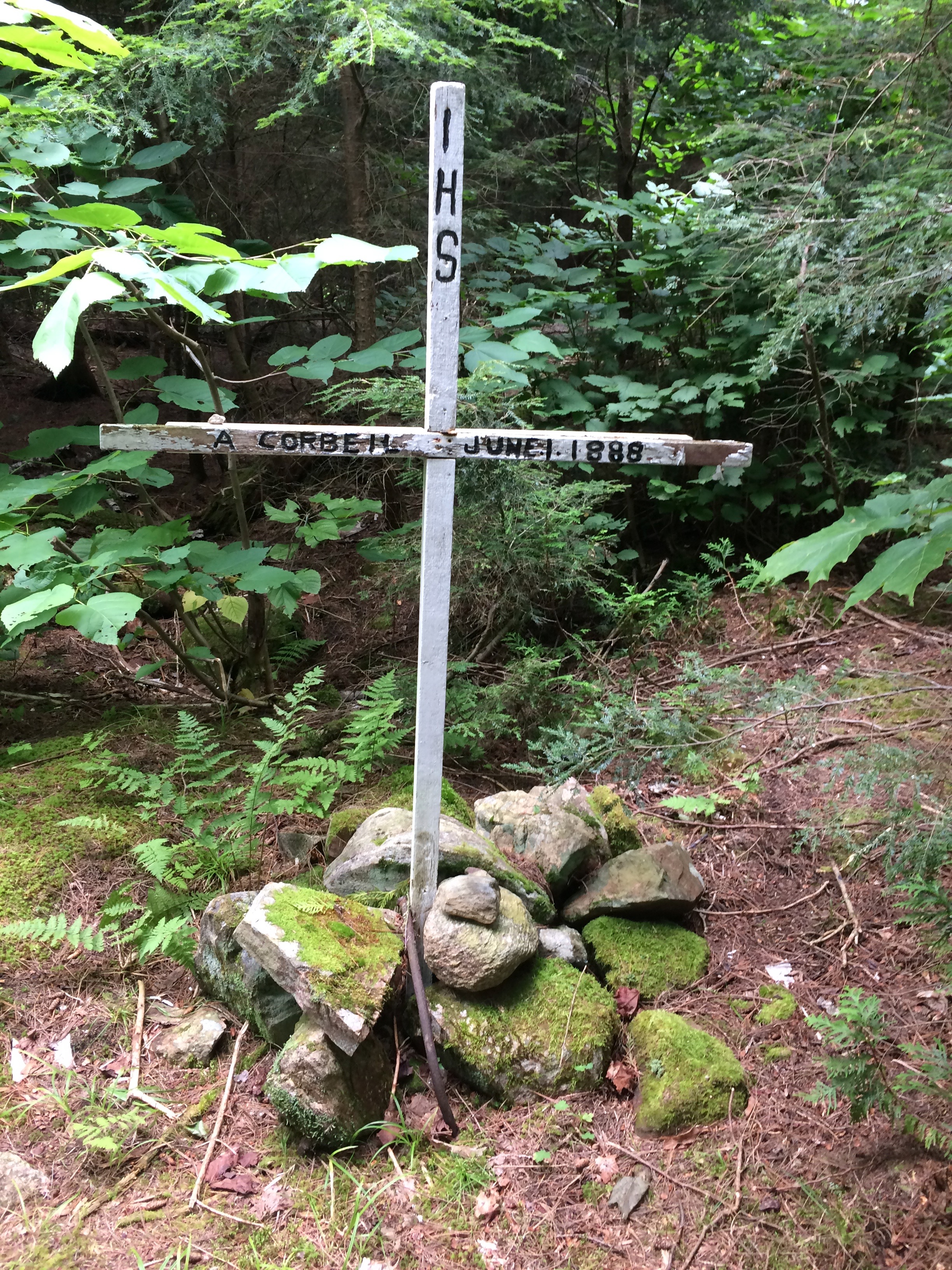
Once we’d appreciated the waterfall, we moved on and finished the portage. There’s a grave marker just off to the side at the top of this carry. I saw this marker for the first time back in 2017, and it was pretty interesting. The marker is for a logger (I think?) named A. Corbeil who died on the river in June 1888. It’s well worth checking out as it gives you a tangible feel for the history of the area. Don’t believe me? Ask future Drew, who is definitely going to remember to check it out the next time he’s through that way, because Labour Day Drew totally forgot.

The Petawawa between the two waterfalls is a relatively placid paddle by early September. Sure, there’s a bit of a current (and a whole lot of a current going over the falls), but it’s barely noticeable. It didn’t take much time to get from the p690 to the p290 that takes you around the second waterfall, and it didn’t take much time after that to get from the p290 to the start of Unicorn Hill.
Placid is not a word I would use to describe Unicorn Hill.

Let’s start with the basics. Unicorn Hill is the name given to a p2400 that takes you past Stacks Rapids on the Petawawa River. It takes you from around 339 meters above sea level at the start (coming from Cedar) to 408 meters above sea level at the height of land. 70 meters of climbing over 2.4 kilometers isn’t the end of the world, but it’s not nothing either. The grade of the hill isn’t even that bad. For the most part it’s a gentle upward slope. However, gentle as it might be, it’s also relentless. Once you start climbing it feels like you just. don’t. stop. Mark and I had the boats for the first part of this carry, and I kept telling myself I’d get it to the height of land at about the halfway point before handing it off. While my pride was down with this plan, my legs and back were not. With what I later realized was about 100 meters to go to the top, they took a vote and decided to join SAG on the picket lines (ooh, fun, an already very dated reference. I wrote this thing back in September, but haven’t had time to format it until now. Turns out a lot can change in four months, who knew?). But, you know what? The only thing better than getting to the top of Unicorn Hill with your canoe is watching someone else get your canoe to the top of Unicorn Hill (and beyond).


By the time we were across that portage it was just past 4:00 pm. That was fine. Catfish was our day one destination, so all that was left to do was find an open campsite and settle in for the night. I didn’t much care where we stayed, I just knew that I didn’t want to stay on site 11. I’d stayed there years before and, along with some unpleasant memories of spending half the night getting reacquainted with my dinner thanks to a particularly nasty stomach bug, the words “dank hole” are inextricably linked with it in my brain. That said, I wasn’t overly worried about a return visit. By my count, Catfish has 14 campsites, and I knew that as of the night before it had not been fully booked out. I figured finding a site would be quick and easy, especially since most of Catfish’s sites are on the main pass through route. We’d just grab the first open spot we found and all would be right with the world.
Sigh.

I don’t know if people were staying off permit or if there was a run on reservations after my last check, but Catfish was hopping. Every site we passed had someone on it. Each time I’d get my hopes up as we rounded a corner and didn’t immediately see signs of life on the site and each time those hopes would be dashed by a flash of colour through the trees or someone sitting by the water, enjoying a quiet evening with absolutely no consideration for the fact that I wanted that to be me sitting by the water enjoying a quiet evening, not them.

Catfish is made up of two main basins. The first quarter is where you come out of the Petawawa from the direction of Narrowbag. It’s got a few sites on it (all of which were taken) and connects to the larger ¾ of the lake by way of a short and shallow narrows section Gordon called its mushy middle. There actually was an open campsite in the mushy middle, but it was surrounded by lily pads and looked like a great spot to run some experiments on how quickly a swarm of mosquitoes could exsanguinate four healthy adults.
We kept going.
Our luck wasn’t any better once we got into Catfish’s larger section. The majority of the sites in that section are on the eastern shore, and all of these were occupied. By the time we got to Shangri-la island (which looked deceptively empty right up until we were right in front of it), I was realizing that when 2017 Drew told himself he’d never have to stay on Catfish’s site 11 again, he hadn’t understood that never has a six year expiry date.
Ladies and Gentlemen: I give you Catfish, Site 11, the 2023 edition.


So what’s wrong with site 11? Honestly, it’s more a question of what’s right with site 11, and the answer is “not all that much”. Located on the north side of the island that marks where Catfish makes its western junction with the Petawawa, the main knock against this site is that it’s just uniformly underwhelming. The site is fronted by a wide sand and gravel beach. Sounds nice, right? Well, the problem is that beach is fronted by a frog’s fever dream worth of lily pads, making for a not particularly pleasant swimming spot. Moving inland, the site proper is a not that short of a hike into the interior of the island. Once you get to the clearing, it’s an enclosed, kinda gloomy space (fire pit is pretty good though). There’s a shallow mucky area just through the trees to the east and west, relatively dense brush to the south and the thunderbox is down a very short path between you and the beach to the north (This is the only site I’ve ever found in Algonquin where the thunderbox is closer to the water than the fire pit. Nothing better than answering nature’s call while saying hi to your buddy who’s wandering by on his way to refilling the water filter). On the plus side, this is a sheltered spot, so it would be a decent option in the early spring or late fall. On the negative side … pretty much everything else.

Once we were settled Mark, Gordon and I braved the lily pads and went for a swim. We ended up towards the eastern end of the island where the water plants petered out. Despite the seemingly clearer water, I somehow managed to dive through the only clump of slimy green stuff in the area. Swimming done, and ick meter refilled, it was time for dinner. Mark and Gordon were working on a delicious looking steak and potatoes meal. They grilled the steak over the fire and wrapped the potatoes in tin foil and put them right in the coals. I went with a rice wrap with veggies and cheese. The last few trips I’ve been bringing along the Ben’s Bistro Express packets for dinner, and I’ve got to say I’m liking these in comparison to my usual Alpinaire dehydrated meals. They’re certainly more cost effective, and you can pair them with a bunch of different options to keep meals interesting (that said, nights two and three were 100% me eating out of a bag, so it’s not like I’m revolutionizing things here).
The weather for day one had been phenomenal. It was beautiful and sunny all day without getting too warm, and it stayed comfortable as the sun went down and the thermometer started to drop. We alternated between chatting by the fire and standing on the beach, watching the stars come out. The sky was gorgeous that night. Not a cloud to be seen and a blanket of stars overhead. By the time I crawled into my tent for the night there was a slight chill in the air, but not enough to make it unpleasant. In fact, it was the perfect temperature for sleeping, which is exactly what I did.

We had a long way to go for day two. Our goal for the night was Philip Lake, some 20+ kilometers to our southeast. To get there we had to pass through a handful of lakes and tackle multiple KM+ portages. My hope was to get on the water early as I was targeting a very specific site on Philip and reservations in the Park are first come first served. You book your destination lake, but all that guarantees you is a spot on that lake, not any particular campsite. I’d been told that there was a definite drop off from the best site on Philip to the rest, so I didn’t want to risk losing it to another group who happened to get going half an hour before we did. I was also a little concerned about what Hogan Lake might look like by mid day. Hogan is a massive lake about 10 kilometers south of where we were starting. We had to pass through it to get to Philip, and if there is any kind of wind it can get tricky. I figured the earlier we got to Hogan, the better our chances of avoiding a wind. With all that in mind, we ate a quick breakfast and were leaving our site by 8:30. (I’d like to say that this was the last time I’ll ever stay on that site, but we all know better).

The paddle out of Catfish follows the Petawawa for the first kilometer or so. This is a nice stretch. The river is wide and the turns are gradual. There are a couple of lily pad mats at various corners, but otherwise it’s a deep, easy paddle. Which is nice, because “Deep, easy paddle” are not words that I would use to describe whatever that muck is in between the Petawawa and Sunfish Lake.
To get down to Sunfish from Catfish you have to pass through a couple of football fields worth of wide open, shallow, lily pad infested water. The path south isn’t immediately obvious from the river until you’re right on top of it, and then when you do see the break in the lily pads you wonder if it’s the actual route or one of those magic eye illusions where if you stare at the mess in front of you for long enough you have a minor stroke and start to see something. The route twists and turns towards Sunfish, offering a couple of opportunities to stop and ask yourself if you’re still going in the right direction. Eventually, the lily pads end and you’re left with (an actually very pretty) Sunfish Lake proper.

There are no campsites on Sunfish. It basically exists as a lily pad sanctuary and to get you from Hogan to Catfish. There is an option to head deeper into the lilies to check out Calumet and Cuckoo Lakes just to the west of Sunfish, but we left that side quest for future Drew. Instead, we pulled up to the p1070 south to Newt Lake and got ready for the first of three long-ish portages in between Sunfish and Hogan.

My main impressions from this stretch are of burning leg muscles interrupted by nice, but small, lakes. The portage to Newt is a great chance to remind your quads that you hate them. It offers a particularly steep bit right near the start, and then keeps climbing even as the grade levels out. By the time I arrived at Newt I was soaked with sweat and relieved that I’d made it across the portage without anything popping. Newt Lake was quite pretty. It’s small. There are no campsites here, and you’ll be across it in the amount of time it’s taken you to read this paragraph. But I thought the shoreline scenery was nice, and I really liked the view from the portage put-in.

The p750 between Newt and Manta felt better than the Sunfish to Newt carry, probably because it was Vince’s turn with the canoe. There was still a decent amount of up and down on this portage, which makes sense as Manta was the highest lake on our trip. Technically, it was all downhill from here. Just don’t tell that to the P1845 between Manta and Hogan, because it sure felt like I was back on my stairmaster for parts of that carry. This is one of those portages that gives you that flash of blue way too soon. There’s nothing worse than rounding the corner of a long carry, seeing that flash of blue, thinking you’re almost done, then following the portage for another (estimated) million kilometers as it tracks the shoreline for a while before getting you to the put-in.
After spending the better part of two hours on small lakes and long portages, Hogan was a welcome sight. Hogan is a huge lake, and I love big lakes. We came out of the portage at the foot of a mid-sized bay at Hogan’s midpoint and were greeted with a gorgeous expanse of blue. A less welcome sight was the array of white caps marching steadily east at the top of that portage bay. The good news was that those waves were going in the right direction. They’d be pushing us towards Philip, not away from it. The bad news was, judging by the lack of movement in the canoe I could see that was heading in the other direction, it was a very strong wind. Strong winds, even when they’re tailwinds, can be a challenge. And I was curious as to how difficult it would be to keep navigate once we were in the teeth of it.
Kind of! As it turns out.

Getting out of the bay was easy enough. There was a side wind, but the curve of the far shore sheltered us from the brunt of it. Once we got out onto Hogan’s main drag (All of Algonquin, where most of our slang comes from 50’s Archie comics), it became more difficult. Coming out of that bay the shoreline gradually turns east, with a few points and bumps along the way. As a result, paddling out of the bay and following the path of the wind dead east wasn’t possible, as we would have to get around those points and bumps along the way. This meant that we would periodically have to turn our boats broadside to the wind and paddle like crazy to get far enough towards the middle of Hogan that we’d clear the shoreline once we turned east again. I held my breath a bit each time we had to do this, but we managed to get ourselves down Hogan without getting wet (well, too wet. We definitely got boarded by a few rogue waves).
We considered stopping for lunch on a point site just at the mouth of Parks Bay, then we actually checked out the site and realized that we’d be better off looking for a nicer spot, maybe something burning tire fire adjacent? (Ok, that site’s not that bad. It just didn’t look all that good, either.) We kept moving, and I’m glad we did. Across the water, just south of the entrance to the Little Madawaska River, we found our spot. This campsite is at the foot of a small bay. The site is fronted by a small beach, and has a very nice fire pit area and site proper. Even better though, is the rocky point a short walk to the north. This point juts out into Hogan and has a spectacular view across the water. There were plenty of spots to sit on the sun-warmed rocks and watch the waves while we ate our respective meals (PB and Honey with steak strips is an underrated lunch). The wind was still blowing like an industrial hair dryer, rolling white caps up against our point while the tops of the waves sparkled and danced in the sun. Sunny skies, gorgeous scenery and a delicious lunch, sounds awful, doesn’t it?


I’m going to be honest here. There’s a two hour gap in my photos from this day from the (muddy) midpoint of the final portage of the day, a P1495 along the river, to sometime after our arrival at our site on Philip. This isn’t unusual for me. As the day wears on the volume of pictures I take goes down as my willingness to put down the paddle and pick up the camera is outweighed by a desire to just. Get. To. The. Site. However, what is unusual is that I’ve got pretty much no memory of what the Little Madawaska was like after that final portage. There was still about a kilometer of paddling from where we ended the carry to where we entered Philip and I’m assuming that my lack of recall means it was a decent paddle. But, who knows? It’s equally possible that the Little Madawaska Aliens wiped my memory after subjecting me to all manner of probes. Either way, the next thing I remember is paddling out onto Philip Lake into a tailwind that hadn’t died down much at all since we’d left Hogan.

I had been told Philip’s south shore campsite was worth checking out. After striking out on Catfish the day before, I’d been convinced that we were going to arrive on Philip and find it already taken. But, just like they’d done for pretty much everything else that day, the tripping gods were smiling on us. Coming out of the river we had a clear view to the campsite on the opposite shore. It’s tucked in a small, westward facing bay with a beautiful beach and a nice rocky outcrop protecting it from the north. And, even from across the water, we could see that the beach was empty and the site was free!
Awesome.
We made our way across Philips. That paddle was actually a bit of a challenge. The wind was strong and we were taking it at an angle. I remember thinking how glad I was that we weren’t trying to go the other direction, because that would have been brutal (hold that thought). After a few hairy minutes we arrived at the campsite, grounding our canoes on the soft sand before hopping out to explore our home for the night.
What a great spot.

This site sits at the bottom of a steep, blowdown covered hill. The site itself occupies a small, flat area behind the beach. There’s room enough for a few tents, and a very nicely situated fire pit just back of the beach. The highlight of the site is the beach and the rocky point at it’s northern end. The site is very well protected from the east and extremely exposed from the west. This meant that we had the wind blowing through our site all night, but that was fine. It was a warm night, and the wind really just kept things comfortable.
We got set up, took a nice long swim and settled in for a low-key afternoon.
And then we met our parallel universe selves.

Sometime in the late afternoon a canoe rounded the small point at the edge of our site. I could hear the paddlers talking to each other. They sounded a lot like we had on Catfish the night before. Disappointed, and tired. They pulled up to our beach and told us about their day. They were on their second day of trip, coming from Radiant that morning. It’s about 15 kilometers from the middle of Radiant to that site on Philip, and they’d been fighting the wind and the current the entire way upriver. The final stretch on Philip was particularly bad. The wind hadn’t died down at all. If anything, it had gotten stronger. Where we were we could see white caps blowing across the water, and we were only seeing the windward side of the lake. Further east, it was worse.
They weren’t alone. The rest of their group washed up on the beach over the next ten minutes or so, all of them various degrees of disappointed to find the site already occupied. We chatted for a few minutes. Like us, they were a group of friends who did an annual September trip. Like us, they’d planned to go clockwise out of Cedar, with permits for Radiant, Hogan (Philip was fully booked) and Catfish. Unlike us, they didn’t rethink that plan at the last minute and turn things around. And, unlike us, they’d had a very tough day.
It’s nice when the universe lets you know you made the right decision.

Eventually, they moved on. While their permit was for Hogan, they decided to stay on one of the north shore sites on Philip as it was another 10 KM of river to Hogan, they were tired and the afternoon was rapidly turning into evening. That’s a completely defensible decision in my opinion. The Park typically issues fewer permits than there are sites on a lake for exactly that scenario. There will usually be at least one extra site available on any given lake in case of sickness, weather or other delays. What was less defensible was them not having a permit for Philip and targeting the nicest site on the lake once they decided they couldn’t keep to their route. Philip was fully booked that night, meaning they would have been taking that site from a legitimate permit holder. I can tell you that if we’d arrived second and found them set up, knowing that they didn’t have a permit for Philip, I wouldn’t have been happy. In that scenario, if I were the one camping off permit on a fully booked lake, I would have headed for one of the less desirable sites along the north shore to start with.
But, enough about that. In the end both groups had places to stay after a hard day, and we got a glimpse into the darkest timeline.

The sunset that night was spectacular. That rocky point is the perfect spot to sit and watch the sun go down. As the sun dipped towards the trees it started illuminating the wisps of cloud stretched across the sky from below. First the edges of the clouds were lined silver, then they were painted orange and red, and then it seemed like the entire sky was on fire. It was gorgeous.
Once the sun was down we retreated to the fire pit, breaking away every once in a while to stand on the beach and watch the stars. It was the perfect end to a perfect day of tripping. As I crawled into my tent at the end of the night I realized that I couldn’t remember a better day on the water. Pretty much everything went exactly as I’d hoped. The route down from Catfish to Hogan was challenging without being exhausting. Hogan and the Little Madawaska were fun paddles and Philip had surpassed all expectations. Would that be the case for tomorrow as well? I wasn’t sure, but I was looking forward to finding out.

We were on the water just after 9 the next morning. The wind had blown itself out overnight, which left us a calm start to the day. The paddle along Philip was a nice warm up. The Little Madawaska exited Philip out the southeast corner of the lake, taking us past a decent looking beach site and back into the tall grasses that had marked much of yesterday’s time on the river.

It was a short paddle to our first portage takeout of the day. We only had two portages in between us and Radiant, but they were long. The first was a P1085 that starts in an historic zone that used to be home to the Philip Lake Depot Farm, and the second (some 5+ kilometers further along the river) was a behemoth of a p3565 carry that, at that point in the morning, was a problem for future Drew.
The p1085 was a really nice portage. It must have been a road at one point (and may still be used as one for four wheelers) because it was flat, wide and easy to follow. It had what felt like a subtle downhill grade pretty much the entire way, and I was pleasantly surprised when it deposited me back on the Little Madawaska so quickly.
And then it was time to paddle.


Having escaped the hordes of Uruk Hai, it was time for the p3565.

You know what? For 3.5 KM of boat hiking, this wasn’t a bad carry. To start, this is a very pretty portage. For the most part it follows a rocky section of the river, running alongside the water before curving into the woods and back again in a few places. The elevation changes aren’t bad. There are certainly some ups and downs, but nothing leg busting (or, nothing leg busting that I carried. I seem to recall one unpleasant up and down while Vince was carrying our boat). The biggest issue I ran into on this carry was technology related.
Ugh. I feel like that last sentence was basically a record scratch stop in the flow of this report. Why on earth am I talking about technology issues on a canoe trip in Algonquin Park?

Here’s why. I’ve been a longtime fan of Jeff’s Map. Between his original map and his recently released (and updated) version from Map’s by Jeff, Jeff has been creating the most detailed and information oriented maps of Algonquin for years. On top of the wealth of detail, he also makes his maps available for download and compatible with a GPS app, so that if you are in the Park, looking at the map on your phone, you can see exactly where you are on the map. I love this feature. It does nothing for my orienteering skills, but it’s come in handy more times than I can count. It has, however, made me very reliant on it as well. Which is why I ran into trouble on this portage.
See, for the most part, Jeff’s original map is extraordinarily accurate. The little blue dot marking your GPS location on the map will almost always line up with where you are in real life. In the case of the P3565, that’s not entirely correct. On that map, the portage is shown as a gradual curving line, like it follows a road. In reality, it follows the river and gives you all the little meanderings you’d expect with that. That’s fine. As long as the portage path was easy to see (and it is very easy to see) it didn’t really matter what the GPS told me. However, the GPS was also showing me closer to the end of the portage on the screen than I was in real life. The map showed the portage ending well before it finished. As a result, my internal sense of when the portage should be over, was off, and it felt like I was running on empty for the last 500 meters or so.
Don’t get me wrong, this is a me issue. I shouldn’t be so reliant on that blue dot. The portage ends when it ends. Constantly checking to see how much distance is left isn’t going to get me across the finish line any sooner. If nothing else, this was a good reminder that sometimes (always) it’s better to just put the phone away and enjoy the journey. It did, however, make for a much longer seeming portage than it probably would have been otherwise. The good news is that Jeff’s new map, (out now from Maps by Jeff and also available for download to your GPS app!) has updated this segment, and looks awesome, too. Check out the side-by-side comparison below, then go order yourself a copy if you haven’t already! (Seriously, pick this map up. It’s filled with useful information and there are some great new features that have been added. My favourite is the portage profile graphic that shows you the topography of each portage before you start it. Super useful).


Step 2: Say hi to some Alder
The portage ended at a fast-moving section of the Little Madawaska. Gordon and Mark loaded their canoe first, and in doing so gave Vince and I some valuable insight into how not to launch our own boat (unless our goal was to get immediately swept into a nearby clump of alder, in which case they gave us a picture-perfect case study in what to do). It was a close call, but by loading the boat and pushing off at the furthest edge of the upstream end of the put-in, we had just enough clearance that the current pushed us past the outstretched alder, not into it.
From here it was a very nice paddle down the river into Radiant. The Little Madawaska through this stretch reminded me a lot of paddling through a city park. The banks are more open, with the occasional hardwood dotting the shoreline here and there. The sense of paddling through civilization was heightened by the rail bridge we passed under, the remains of some old dock pilings we passed by and the three (at least!) sunken tires we paddled over.


Radiant, when we arrived, was beautiful. The sky was a deep, clear blue overhead, the sun was shining and the day was hot. We decided to stop for lunch on one of Radiant’s sites before heading to our final destination for the day, Clamshell Lake. We pulled up to a site on the west shore, just below the mouth of the Petawawa, and immediately fell in love.
This site is awesome.

Located on a rocky … I can’t quite call it a point, let’s say corner, of Radiant as it turns into the Petawawa, the site sits about 15 feet above the water on a level patch of rock. Just west of the site is a high, sloping, smooth rock face that offers a great view east on Radiant and left me wondering just how bad an idea it would be to bring a flying saucer sled with me the next time I visit this site (and there will definitely be a next time). I settled on very bad, there’s a reason rock sledding isn’t a thing, but also very fun? At least, very fun until the pain from whatever bones I’ve broken kicks in.

However, that hill isn’t the highlight of the site. It’s not even second place. Better than the saucer sled hill of death is the Muskoka chair style bench beside the fire pit. I’m not talking some bushcraft collection of random sticks and rope. This thing was built with actual 2x6s and at least some understanding of chair construction. And, even better than the bench?
The swimming!
The Radiant side shoreline is a collection of rock ledges, some of which are perfect jumping spots. We’re not talking 80 foot drops or anything, more like 10 feet at the most, but still a ton of fun. There’s also a spot right where the shoreline turns the corner into the Petawawa that has a low ledge that worked as a diving platform (like I say every time I talk about jumping ledges in the Park, please please please don’t take my word for whether or not it’s safe to jump from a certain spot. Always, always, check for yourself before jumping or diving in the Park).


Great swimming, an awesome site set up and the birthplace of the new Olympic sport, Extreme Rock Sledding? What more could you ask for?
After spending some time eating lunch and jumping off ledges, the general consensus answer to that last question was “nothing”. This was the ideal site for us and would make a great spot to stop for the night.
Except.

Except remember how high and mighty I got about those guys staying off permit on Philips? Well, if we stayed on Radiant we’d be doing the exact same thing. Our permit for that night was on Clamshell, and it was on Clamshell because Radiant had been fully booked when we re-routed a few days earlier. As much as we wanted to stay, it wouldn’t have been fair to whoever actually had a permit for Radiant. After a last ditch check-in with my wife, who very kindly checked with the Park and confirmed that there had been no cancellations on Radiant over the past couple of days, we got back on the boats and continued on to Clamshell, sure that the best part of the day was behind us.
At first, that certainty seemed well earned. It was a short paddle to Radiant’s northwest corner, and from there we turned our canoes into a stretch of the North River, headed for Clamshell. In between Radiant Lake and Clamshell Lake is a fun little lily pad sanctuary called Shoal Lake. You get to Shoal by way of a p20 that is basically just a lift around a rocky stretch in the river (it’s also the only place all trip where I got my shoes wet). Then you’re on Shoal and wondering who in their right mind would book the one and only campsite on the lake.

The Radiant end of Shoal is very shallow. There are rocks guarding the portage entrance/exit on both sides, and the lily pads have made themselves at home. It’s a small lake, and things get a little deeper/better on the east side of the lake, but at no point did I think I’d ever want to stay here. As we paddled over a set of barely submerged boulders guarding the entrance to the P135 up to Clamshell, I found myself wondering how just how bad Clamshell would be given that it’s right beside Shoal and about the same size.
As it turns out, not bad at all! In fact, Clamshell was kind of awesome.
I could see that Clamshell was a totally different kettle of (shell)fish as soon as we arrived. Clamshell is a small, oval-ish (if you squint) lake. The lily pads are few and far between, and the water seemed clear. You can see the lake’s sole campsite from the portage put-in, and it looks like it’ll be a nice spot to spend the night. Sitting on top of another rocky outcrop (I love me a rocky outcrop), it’s located beside the outlet of a set of falls coming down the North River and just across from the portage that goes around those falls. As we paddled the last half kilometer or so to the site, it sure seemed like we’d lucked out.
And then we found the rope swing.

Wrapped around an old pine that stands on top of a small ledge right at the water’s edge, is a rope. And that rope is perfectly placed to swing you out over (and into) the lake until you’re good and waterlogged. It turns out that a very, very long time ago a very, very large waterfall emptied into the basin directly in front of that Clamshell site. As a result, the water directly in front of the site is 210 feet deep, which is probably deep enough for rope swinging. I wasn’t able to confirm the depth for myself, sadly I can only hold my breath for 209 feet, but I can confirm that the rope swing is awesome.

The only drawback I see to this site is that it’s not great for tent placement. There are two decent pads near the fire pit, but that also means there are two decent pads in range of campfire sparks. As much as I enjoy Swiss cheese, I don’t want my tent’s fly to look like it. There’s another good spot right by the rope swing, and that’s about it. If you’re working with more than one ground tent you’re going to end up with someone playing camp fire roulette. If, like me, you’re working with an aerial tent, you’re going to quickly realize that this site was not designed with hammocks in mind. The best spots to hang my tent were too close to the fire for comfort or would have had me sleeping on top of Mark and Gordon down by the water. So I ended up setting up in a rocky gully behind the site, hoping that I didn’t run into any inquisitive bears or flash floods (or inquisitive bears caught up in flash floods) overnight.

Once we were set up and finished swimming, Mark and I decided to walk the portage along the waterfall to see what we could see. I’m glad we did. Towards the top of the portage we followed a faint trail down to the river and found a spot on a flat, rocky plateau in between two small sets of waterfalls. It was very pretty, and since it doesn’t have a name on the map Mark has named it Czernik-Thompson Falls as we were obviously the first people ever to see it. You can call it Czompson Falls (pronounced Chompson) for short.
Once we’d had our fill of appreciating Canada’s newest named water attraction we headed back to the site. Even though it was past 6 pm in early September, I was hot. I didn’t know it at the time, but we were heading into a 30 degree plus heatwave over the next few days, and that night was a preview of what was to come. The air was still and humid and the water was cold and inviting. Figuring out what to do once we got back to the site was easy. You don’t say no to rope swings.
The night wound down as the previous two had, with time around the fire and time watching the stars. I retreated to my isolation zone around 10 pm and promptly fell into a deep, sound sleep that lasted exactly three and half hours. I woke up around 2:00 to answer a call of nature that sounded a lot more like a shrill scream by the time I talked myself into getting out of the tent to answer. Unfortunately, while I was bargaining with my uncooperative bladder the rest of my body was waking up too, with the net result that I was wide awake from about 2:00 to 5:00.
But at least I got an early start for day 4?


That first segment of the Petawawa, from Radiant to that p800, is a lovely paddle. It’s wide, and mostly straight. Basically, it’s an actual river, unlike some of the other “rivers” in the Park. The scenery is quite nice, a mix of rocky shoreline and (sometimes) towering pine.
You know what’s not quite nice? That p800 portage. Ugh. On this trip we did the 2.4 KM Unicorn Hill carry. We did the KM+ portages between Catfish and Cedar. We did a 3.5 KM power walk along the Little Madawaska into Radiant. And this portage, this 800 meter portage, was my least favourite of the trip. And it wasn’t close.

To start, this thing is uphill in the way that you expect Unicorn Hill to be uphill, but isn’t. What do I mean by that? It’s steep. On the downstream end of the carry, so, at our end of the carry, you take a couple of level steps and then you take a whole lot more un-level steps. The main part of the hill lasts for about the first third of the portage, getting steeper towards the top while throwing in a loose, gravelly section to help you test your shoe’s traction (and find it wanting, in my case). Once the carry levels out, it’s still not that much fun. It’s a narrow trail, with lots of ups and downs combined with uncertain footing and all the tripping hazards you could ask for. Towards the upstream end, the path gets kind of mucky as well, in case you weren’t finding the rocky, root-y, narrow path frustrating enough. I dunno. The best thing I can say about this portage is that it ends (hats off to the family of four that was doing this portage at the same time we were. The two kids were handling that thing like seasoned experts, and with far less whining and complaining than I was doing).
The good news is that once you’re done with that portage you’re onto an interesting, if short, segment of the Petawawa. Almost immediately after we pushed off we saw an old rail bridge on our right, spanning the river and I imagine looking not that different than it did the day it was built. The river twists through a couple of dog legs after this, passing a cool rock face and a couple of small islands before letting you out at the mouth of one of the prettiest sets of rapids I’ve come across in the Park. All in all, it makes the slog up that p800 worth it. I guess.


The next portage is just past that outlet and again it felt like it was punching above its weight given that it’s only 650 meters long. I guess I shouldn’t have been surprised that a series of portages that take you upriver past sets of rapids and small waterfalls would include some uphill, but I’ve learned to never underestimate my capacity for not thinking this kind of thing through. In my head we had three <1K portages. Easy, right?
That p650 can be cut down to about a p575 if you don’t mind dragging your boat through a narrow spot in the river. Just before the end of the carry there’s a path down to the water that’s clearly been used as a put-in before. The immediate area around the early put-in looks good, but to get out to the river proper you need to thread a slightly too small needle of rocks and shallow water. Like you’re trying to squeeze between your loud and slightly problematic second cousin’s chair and the wall at the end of a big Thanksgiving dinner. I made it, but not before adding some abstract art to the hull of my recently repaired canoe (oh, I should plug Johnny’s Boat Shop in Huntsville. He did a great job patching up my well-travelled Swift Winisk. Got the job done quickly and at a very reasonable price).

The next segment of the Petawawa was quite nice, but honestly at this point I was ready to see what Cedar held in store for us. All trip I’d been half expecting to arrive at Cedar’s east end and find an army of white caps marching towards us. That seemed less likely given that there was barely a hint of breeze in the air as we made our way up the Petawawa, but if any lake can manufacture unpleasant paddling conditions out of nothing, it’s Cedar.
Not this time!

Cedar was smooth as glass when we arrived at the end of the last portage. It was also hot as freshly fired glass, but I’ll take a bit of heat at the end of a trip over a lot of headwind any day. We took a minute to have a kind of awkward looking group picture taken by some fellow trippers and then set off for our last few kilometers of paddling. (Chris Prouse and her family were camped at end of this portage so I said hi and introduced myself. If you’re not familiar, Chris and her wife have a popular youtube channel where they do the kinds of trips that I can only dream of. I think they have the record for the fastest time on the Meanest Link, which is impressive. We’re talking 80 km days through Algonquin. I’m happy if I cover 80 clicks over an entire trip).

That last paddle was gorgeous. Mark and Gordon were just off to our right, their canoe and its reflection cutting through the water, the ripples of their wake the only disturbance in the water’s surface. We stopped for a quick snack break, floating just off a small island about two kilometers from the access. Coming from that direction, you can see the access point from a long way away. For a while, it felt like it wasn’t getting closer no matter how many times I looked up. And then, it felt like it was too close as the reality that the trip was almost over got harder to ignore with every paddle stroke.
And then we were done. The last hundred yards went both slowly and quickly and before I knew it we were pulling up on the beach at Brent to the sound of our canoe grinding up the sand and the chatter of multiple other trips who were finishing at around the same time. We ended as we always do, with chocolate chip cookies and Doritos. This time around we also threw a swim into the mix, wading back into Cedar after the canoes were on the cars and cookies were mostly disposed of.

