It’s been a strange summer for canoe tripping. I don’t think a single one of my trips has happened when or how I originally planned them. When I first started booking permits back in March I was supposed to be on Basin Lake in May, Hilly Lake in June, looping out from Rain Lake in July and up to North River in August.

So far, I’m batting 0 for 4 in terms of fulfilling March Drew’s tripping dreams. Basin Lake in May turned into Basin Lake in June thanks to the COVID lockdowns. Hilly Lake in June and North River in August didn’t happen at all, although I did end up getting to Parkside Bay, Tom Thomson and Joe Lake on some family trips instead. Finally, July’s Rain Lake loop turned into my most recent trip, a four day August zig zag that started at Rain Lake and ended at Canoe Lake.
In other words, I’m going to stop making plans in March.
But enough about my poor planning, let’s talk about a canoe trip. (Editor: Isn’t that kind of saying the same thing, Drew?)
This trip was meant to be my big trip for the summer. Originally, it was going to be a six day loop out of the North River area with a buddy. Unfortunately, that buddy wrecked his knee a few weeks ago and thought that grinding it across a week’s worth of uneven portages might not be the best rehab decision. This meant that my early August trip was now going to be a solo paddle, and it also meant looking at a new route as the one we had planned was one I preferred to do with someone.

The thing about the Park immediately after the August long weekend is that it’s busy. Like, open up the reservation system and be greeted by a sea of red triangle icons and a laughing emoji waving its finger at you busy. When I went to book my new route it ended up being not as much about where I wanted to go as what I could get.
Enter Rain Lake.
Rain Lake is an access point lake on the Park’s west side. You get to it by way of a winding gravel road out of Kearney. (Kearney is the small town that is the jumping off point for three of the Park’s highway 11 access points). It’s a long lake. About five kilometers from the access point (at the west end), to the portage over to Sawyer (at the east end). Three of those kilometers are along a narrow section that could easily be confused with a river. The lake opens up for the last couple of kilometers, but it never loses that narrow vibe. Basically, it looks like Rain Lake has a tail. Or, as a friend of mine once put it, like whoever was designing the lake sneezed.


I’ve paddled through Rain a few times. I would say my opinion of it is neutral. It seems like a nice enough spot. I don’t think I’d want to stay there, but I can’t fault anyone who does. However, as a starting point for a trip, and in particular as a starting point for this trip, it worked well. You can branch off in three directions from Rain, which means that odds are you can find at least a couple of open sites within a reasonable day’s travel from the access point. From there you can build a pretty solid trip through some beautiful lakes, which is exactly what I did.
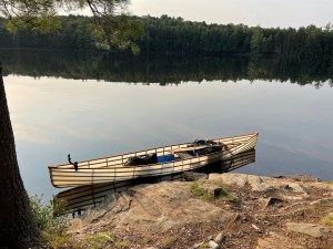 My final route ended up as a three night trip and took me through Islet, Misty and Brule Lakes before heading down to Canoe Lake courtesy of Potter’s Creek (and a whole lot of swearing). It was a portage heavy trip, which was fine because it would also be the inaugural trip for my brand new solo canoe, a sub 30 pound beauty from Backcountry Custom Canoes. Portages become a lot less daunting when the canoe you’re carrying weighs less than a Corgi (they become more daunting when you realize that despite having an extremely light canoe you’re going to to have to double carry anyway, but we’ll get to that).

I arrived at the Rain Lake access point a little after 11 in the morning on the Tuesday following the August long weekend. The parking lot was jammed. It looked like people had started off trying to park their cars in an orderly fashion but at some point everyone just collectively decided to play 52 pickup with their pickups. There were vehicles scattered everywhere, including a few that were double parked so badly the cars behind them would have to sprout gadget wheels to get out. Fortunately, I didn’t have to worry about parking. My lovely and patient wife had agreed to go an hour and a half out of her way and drop me off at the access point. She helped me unload, reminded me my hammock tent effectively turns me into a piñata for bears, and drove away.

Once she was gone, I loaded up the canoe and pushed off. This was my first time paddling my new boat fully loaded and I thought it might take a few minutes to get comfortable. Well, I can’t speak for how the boat felt about everything, but I was comfortable right away. It handled like a dream. It helped that the conditions were absolutely perfect. The sun was high and shining, but not too hot. There was just enough of a breeze to keep the air cool, and that breeze was coming from the west, which meant I had a very slight tailwind. It felt like I was flying down that first river-like segment on my way to the Little McCraney portage. But I wasn’t. Canoes don’t fly. Yet.

I pulled up to the P1695 over to Little McCraney at the same time that another group was finishing their carry. We chatted briefly and they told me that apart from a couple of muddy splotches, the portage was great. And they were right! The only thing remotely challenging about this carry is the distance. Otherwise, it’s a wide, flat cart trail. You can’t really ask for better. In fact, I’d go as far as to say that there isn’t a single ten foot stretch of that portage that would be considered remotely difficult. How can I be so sure? I walked the damn thing three times.
Double carrying sucks.

So, my plan for this trip had been to single carry. I always single carry and I figured with my new, super light canoe, the whole single carrying thing would be a breeze. What I didn’t figure on was my inability to load my canoe pack in such a way that it didn’t stick up above my head, bang against the canoe’s seat directly behind my shoulders and unbalance the entire damn thing. The main culprit here gear wise was my new aerial tent, which remains the most comfortable tent I have ever slept in, but which comes with a set of very solid spreader bars that make its packed shape longer end to end than my other tents. For the life of me I couldn’t figure out how to get it in my pack without those spreader bars smacking into the canoe when it was on my shoulders (of course, I figured out exactly how to do this the day after I finished the trip. I was so focused on getting the tent into the pack it didn’t occur to me to strap it to the outside of the bag).
So I decided to double carry the route. The upside to this was that this meant that I was carrying relatively little weight on either of the loaded trips across the portage. The downside was that it tripled my portage distance. And on a portage heavy trip, that’s a pain in the … well, legs, mostly.

Once I was done getting to know the Rain/Little McCraney portage in intimate detail, it was time to head south. Little McCraney connects to McCraney by a short river. That was a really pretty paddle. There’s just enough widening and narrowing in the river to keep things interesting, and at one point I got to watch a heron fly upriver towards me. This was unusual in that herons usually treat me like a prom date; they notice me heading in their direction and take off. Having one approach me head on was a cool change of pace. (I love herons. I think they’re my favourite wildlife sighting. Every time I look at one all I can think is “you used to be a dinosaur” and for a moment I’m 13 year old me watching Jurassic Park for the first time again).


The river eventually opens up into McCraney Lake. The view south as I paddled out of the narrows was very pretty, but I wouldn’t want to have to go that direction in a headwind. McCraney is a big lake. It runs about 4 KM north to south. Paddling its length on a windy day would be a challenge. Fortunately for me, it wasn’t a windy day and I wasn’t paddling its length. My next portage was the P65 over to Way Lake, a tiny puddle of a lake accessible from McCraney’s north east corner. I paddled across the top of McCraney, pausing to admire a field of gnarled and sun bleached stumps along the north shore, and quickly made my to the Way Lake portage.
Way Lake leads to Wee Lake which leads to Weed Lake. Way and Wee are tiny little things. They’re connected to each other by a low maintenance P570 that has an unwelcome amount of uphill coming from the Way direction. It was on this portage that I experienced the real downside of double carrying. Climbing a hill or picking your way through a mess of brambles and branches is bad enough. Knowing that you’re going to be doing it all over again in about 20 minutes is downright demoralizing.


The P635 between Wee and Weed was better. Not as hilly and despite being a bit longer felt like it went faster. I really liked Weed Lake. It earns its name. You start off with a short, creek-y bit that does indeed have a few weeds around the edges. The creek exits into a lily pad choked bay, followed by a nice stretch of open water before you get back into the lilies and, eventually, the portage over to Islet.


The wind had picked up a bit, giving me a nice tailwind as I paddled through Weed. I stopped in the middle of the lake and took a minute to just listen. I could hear the wind through the trees and lap of the water against the canoe. In the distance, a loon called. On shore, I could see pine trees bent by the wind, growing in graceful curves away from the prevailing breeze. It was beautiful. I remember thinking that it was this exact moment that was the reason I was out there. One of those perfect moments where it’s just you and the Park.
Man, I love those moments.
Anyways, much like Star Trek: The Next Generation, all good things must end (I’ve used this line before. I don’t care). Eventually I shook myself out of my reverie and paddled the rest of the way out of Weed Lake.
Once I was across the P45 between Weed and Islet (pausing to admire the canoe runway leading into the portage on the Weed side), it was time to find a home for the night. I knew which site I wanted. There’s one island site on Islet, and it’s awesome. I also knew that there were other trips booked for Islet for the night, and it was getting late in the afternoon, so I figured it would very likely be taken. I spent most of the paddle coming out of portage bay mentally preparing myself to hate whoever was on the site, then I rounded the final point leading into Islet proper and discovered that … the site was free!


Either I was the first one on the lake or I’d wanted the site so badly I’d Thanos’d the other trips. Whichever it was, I was a happy man.
One of the best things about that site is that it’s got some perfect hammock trees on the eastern end. The last time I was there, I’d set up my regular hammock for an afternoon’s worth of relaxing. This time around I set up my Aerial tent for what would turn out to be one of the best night’s sleeps I’ve ever had on a trip.

Once I had my gear set up I spent some time doing … well, not much. I went for a swim, met my site’s resident snapping turtle (This was my third turtle landlord this summer. In 20 years we’re going to look back at 2021 and be like “oh, that was when the turtles started to take over”. Then we’ll go back to toiling in their turtle mines) and ate some dinner.

After dinner, I paddled across to the south shore and checked out the empty sites that dotted the shoreline. The three that were across from the site were varying degrees of bad. I wouldn’t stay on two of them if you paid me (sites 3 and 5 according to my Campsite Report Archive). The fourth site, so the second southernmost site, was better, but average at best. Of the sites I saw, the only one that came close to matching my island site was the northernmost site along the east shore. This one doesn’t look like much from the water. In fact, it looks kind of crappy. But that crappy veneer is hiding a really big, really nicely set up site behind its pines. There’s tons of space, a well built fire pit area, a good beach-y swimming spot and a nice, if semi-obstructed, view out to Islet. If I couldn’t get the island site this would easily be my second choice (one thing, on the map this shows up as a hike-in site, but there’s a campsite sign clearly designed for canoeists. I don’t know if that means it’s available for both hikers and canoeists, or if it’s just there to taunt people from the water).


Fortunately, for this night at least, I didn’t have to settle for the silver medal. Once I was done exploring, I hopped back in my canoe and headed back to the island. I spent the rest of the night watching the sun set, reading and generally enjoying being smack in the middle of nowhere. I retreated to my tent around 9:30, pleasantly tired and wanting to get a good night’s sleep before the next day’s challenge: a short on the map, long in reality, hop across to Misty Lake by way of Cranebill Lake and the longest portage of the trip.

Related Campsite Reports:
Islet Lake – Site 2
Islet Lake – Site 3
Islet Lake – Site 4
Islet Lake – Site 6
Islet Lake – Site 8